North Carolina High Wind Warning Expands as 50–70 MPH Gusts Target Blue Ridge and High Country Tonight Into Saturday
NORTH CAROLINA — A dangerous burst of wind is expected to ramp up tonight through Saturday, with the strongest gusts aimed at the Blue Ridge Escarpment and North Carolina High Country, where some exposed ridges could briefly flirt with near hurricane-force wind conditions.
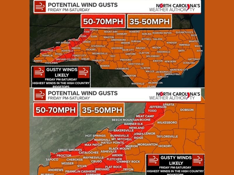
What the Latest Wind Forecast Shows
Forecasters say the highest winds arrive overnight and peak Saturday morning, driven by a tight pressure gradient behind a departing cold front and very strong winds just above the surface.
In the mountains and just east of the Blue Ridge Escarpment, gusts are expected to range 50–70 mph, with a few higher, more exposed ridgetop locations possibly touching 75 mph. Across the valleys and much of the rest of the state, gusts of 35–50 mph may still be strong enough to cause scattered issues through Saturday afternoon.
Where the Strongest Impacts Are Most Likely
The greatest concern is focused on the High Country and higher elevations, including communities and corridors near the Blue Ridge and the Tennessee border.
A High Wind Warning has been issued for a wide swath of mountain counties and ranges, including areas such as Avery, Yancey, Mitchell, Buncombe, southern Jackson, Transylvania, Henderson, Caldwell Mountain areas, Burke Mountains, McDowell Mountains, Rutherford Mountains, Polk Mountains, Ashe, Alleghany, and Watauga—where the odds of seeing 50–70+ mph gusts are highest.
What This Could Mean for Power, Travel, and Safety
Damaging winds can bring down trees and power lines, leading to isolated to scattered power outages, especially where gusts are strongest and soils are soft. Residents should also expect loose outdoor items to blow around and potentially become hazards.
Travel may turn difficult in spots—especially for high-profile vehicles on exposed routes—while dangerously cold wind chills could develop statewide as the air mass turns sharply colder behind the front.
Along the coast, marine conditions are also expected to be hazardous, with a Gale Warning noted for many coastal waters.
What To Do Before Winds Peak
If you’re in the mountains or foothills, the safest move is to prepare for quick disruptions:
- Charge phones and backup batteries
- Secure patio furniture, trash cans, and anything lightweight outdoors
- Avoid parking under large trees
- Plan for slower travel, especially early Saturday when winds peak
Final Word
This is shaping up to be a high-impact wind event, even for areas that don’t see snow—especially across the High Country where the strongest gusts can cause rapid outages and downed trees. If you’re in the warned areas, treat tonight into Saturday morning as the critical window.
Want more weather updates like this in plain language? Send us what you’re seeing where you live and follow along at SaludaStandard-Sentinel.com.