North Carolina Heats Up Into 80s Statewide With Spring-Like Sunshine Before Evening Storm Risk Develops in Western Areas
NORTH CAROLINA — A surge of warm, spring-like air is pushing temperatures across the state into the 70s and 80s today, delivering one of the warmest days of the season so far.
Most of the state will enjoy partly to mostly sunny skies, but a weak disturbance moving in later today could bring isolated storms, particularly across western North Carolina.
Spring-Like Warmth Spreads Across the State
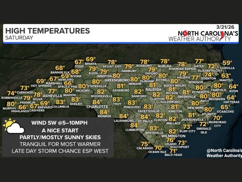
Temperatures are climbing well above average across North Carolina, with many areas reaching the upper 70s to low 80s by the afternoon.
Cities including Charlotte, Raleigh, Greensboro, and Fayetteville are expected to see highs in the 80–84°F range, while mountain regions will remain slightly cooler in the upper 60s to 70s.
Along the coast, temperatures will be more moderated, with highs generally in the upper 60s to mid-70s due to ocean influence.
Sunny Skies Dominate Most of the Day
The majority of North Carolina will experience a quiet and pleasant weather pattern through much of the day, with a mix of sunshine and passing clouds.
Light southwest winds between 5 to 10 mph will add to the comfortable conditions, making it feel more like late April or early May than late March.
This calm setup is expected to hold through the afternoon hours before conditions begin to change later in the day.
Western North Carolina Faces Late-Day Storm Risk
A weak disturbance is expected to move into the western half of the state later this evening, bringing a chance for scattered showers and thunderstorms.
The timing for potential storm development is mainly after 6 PM, with the highest chances across the mountains and foothills.
While severe weather is not expected to be widespread, a few storms could produce gusty winds and small hail, making them worth monitoring.
Eastern Areas Likely to Stay Quiet
Eastern North Carolina is expected to remain largely unaffected by storm activity, with dry and stable conditions continuing through the evening.
This creates a clear west-to-east divide in weather conditions, with the western portion of the state seeing more active weather while eastern areas remain calm.
Residents in western regions are encouraged to stay weather-aware during the evening hours as conditions develop.
Warm Pattern Continues Into Early Spring Transition
The current warm spell signals a broader seasonal transition, as North Carolina shifts from winter into a more consistent spring pattern.
While today’s warmth is welcome for many, the addition of even isolated storms highlights how quickly conditions can change during this time of year.
Meteorologists will continue to monitor how this pattern evolves into the weekend and beyond.
If you’re enjoying the warm weather or see storms developing in your area, share your experience with us. Stay connected with SaludaStandard-Sentinel.com for more updates on changing weather conditions across the Carolinas and beyond.