North Carolina Freeze Alert: Overnight Temperatures Drop Into 20s and 30s Thursday Night Threatening Plants Across the State
NORTH CAROLINA — A sharp drop in temperatures is expected across North Carolina Thursday night as clear skies and colder air settle into the region, bringing the risk of frost and freezing conditions to many communities. Forecasters warn that overnight temperatures could fall into the 20s and low 30s across much of the state, creating potential problems for farmers, gardeners, and anyone with sensitive plants outdoors.
The sudden chill follows a period of milder weather and could catch some residents off guard as nighttime temperatures plunge well below typical early spring levels.
Temperatures Expected to Fall Into the 20s in Mountain Communities
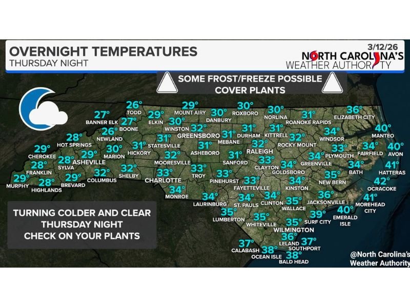
Western North Carolina is forecast to experience the coldest overnight temperatures as the cooler air settles into higher elevations. Cities such as Boone, Banner Elk, Newland, and Todd may see lows ranging from the mid-20s to upper-20s by early Friday morning.
Asheville and surrounding mountain communities are expected to fall close to the freezing mark as well, with temperatures hovering around the upper 20s to near 30 degrees overnight. These colder conditions increase the likelihood of frost forming across exposed surfaces and could damage early-season vegetation in some areas.
Piedmont Cities May Dip Near Freezing
Across the Piedmont region, temperatures are also expected to drop significantly. Forecast projections show cities such as Greensboro, Winston-Salem, Durham, and Raleigh seeing overnight lows generally between 30 and 32 degrees.
Charlotte and nearby communities may see temperatures slightly above freezing, with lows around 32 to 33 degrees expected by Friday morning. Even brief periods near freezing can allow frost to develop under clear skies, particularly in rural areas where temperatures tend to fall faster after sunset.
Coastal Areas Will Remain Slightly Warmer
Eastern North Carolina and coastal communities are expected to remain somewhat warmer due to the influence of the Atlantic Ocean.
Cities such as New Bern, Jacksonville, and Wilmington are forecast to see overnight lows generally in the mid-30s, while coastal locations including Emerald Isle, Hatteras, and Ocracoke may remain closer to the upper 30s or near 40 degrees. Although widespread freezing conditions are less likely along the coast, some inland areas of eastern North Carolina could still see patchy frost early Friday morning.
Clear Skies Allow Temperatures to Drop Quickly
Meteorologists say the drop in temperatures is largely due to a pattern of clear skies and calm winds developing overnight. Without cloud cover to trap warmth near the surface, heat escapes quickly after sunset, allowing temperatures to fall rapidly.
This process, known as radiational cooling, often leads to the coldest temperatures just before sunrise. In these situations, frost can form on plants, vehicles, and other surfaces even when official air temperatures hover slightly above freezing. Because of these conditions, gardeners and farmers are being encouraged to take precautions before nightfall.
Gardeners Urged to Protect Sensitive Plants
Agricultural experts and local weather authorities are advising residents to protect sensitive plants and early spring crops ahead of the cold night.
Covering plants, bringing potted vegetation indoors, or using protective coverings can help prevent frost damage. These steps are especially important for young plants that may not yet be able to tolerate freezing temperatures. While the colder conditions are expected to be brief, the overnight freeze risk could still affect gardens and agricultural fields across many parts of the state.
Residents across North Carolina are encouraged to prepare for the chilly night and monitor updated forecasts as temperatures continue to drop. Readers can also share how the colder weather is affecting their area by visiting SaludaStandard-Sentinel.com and joining the community discussion.