North Carolina Coast Faces Rare “Sting Jet” Threat as Bomb Cyclone Strengthens With Hurricane-Force Winds Offshore
NORTH CAROLINA — A rapidly intensifying bomb cyclone is taking shape off the North Carolina coastline, raising concerns among meteorologists about the potential development of a rare and dangerous atmospheric feature known as a sting jet, which could produce hurricane-force winds, whiteout conditions, and extreme marine hazards late Saturday night into Sunday morning.
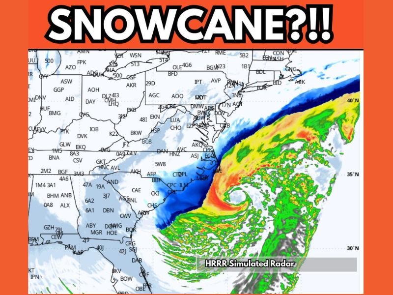
High-resolution forecast guidance, including the HRRR model, depicts a storm structure resembling a compact hurricane as it deepens offshore, with the most intense impacts expected just east of the coastline.
What a Sting Jet Is and Why It Matters
A sting jet is a narrow corridor of extremely intense winds that can descend rapidly from the mid-levels of a powerful extratropical cyclone toward the surface. While uncommon, sting jets are capable of producing wind gusts comparable to Category 2 or Category 3 hurricanes, even though the storm itself is not tropical in nature.
When a sting jet forms, it can cause sudden and severe wind damage over a relatively small area, often catching coastal communities and mariners off guard.
Forecast Models Show Extreme Winds Just Offshore
Simulated radar and wind output from the HRRR model indicates sustained winds of 100 to 120 miles per hour developing just offshore of the North Carolina coast as the bomb cyclone reaches peak intensity early Sunday. These winds are expected to remain largely over open water, but any westward wobble in the storm’s core could bring dangerous gusts closer to barrier islands and exposed coastal areas.
At the same time, heavy precipitation wrapping around the storm could lead to whiteout conditions in areas experiencing snow, dramatically reducing visibility.
Hurricane-Like Structure Despite Non-Tropical Origins
Meteorologists note that the storm’s structure closely resembles that of a hurricane, with a tight pressure gradient, intense banding, and a rapidly deepening low-pressure center. However, this system is driven by strong temperature contrasts rather than warm ocean waters.
Similar sting-jet events have been documented in powerful North Atlantic storms and parts of northern Europe, where they have caused widespread damage despite occurring outside of hurricane season.
Coastal and Marine Impacts Are the Primary Concern
The most severe impacts are expected to remain offshore, posing a significant threat to maritime traffic, offshore operations, and coastal waters. Seas are forecast to become extremely dangerous, and marine interests are strongly advised to remain in port.
Along the immediate coast, strong winds could still lead to beach erosion, minor coastal flooding, and scattered power disruptions, especially in exposed locations.
What to Watch Going Forward
The exact placement and strength of the sting jet remains dependent on the storm’s final track and intensity. Small changes in the storm’s evolution could shift the zone of strongest winds closer to or farther from land.
Meteorologists will continue monitoring high-resolution guidance overnight as the system rapidly intensifies. For continued updates on this developing coastal storm and other regional weather threats, stay with SaludaStandard-Sentinel.com.