North Carolina Braces for Near Record Heat Friday Before Cold Front Brings Scattered Storms and Cooler Weekend Temperatures
NORTH CAROLINA — Near-record high temperatures are expected across the state on Friday, but a shift in weather is on the way as a cold front moves in by evening, bringing a chance of scattered showers and thunderstorms overnight.
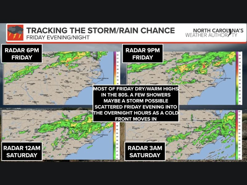
Forecasters say most of the day will remain dry and unusually warm, with temperatures climbing into the 80s across much of the state before conditions begin to change late in the day.
Warm and Dry Conditions Dominate Most of Friday
Residents across North Carolina can expect a warm and mostly dry Friday, with temperatures pushing well above seasonal averages. The buildup of heat ahead of an approaching cold front is expected to create near-record conditions in some areas.
Despite the warmth, the atmosphere will gradually become more unstable as the day progresses, setting the stage for potential evening weather activity. However, not all areas are expected to see rainfall.
Cold Front Brings Evening and Overnight Storm Chances
By Friday evening, a cold front will begin moving into the region, triggering scattered showers and possibly a few thunderstorms. These storms are expected to develop in pockets rather than forming a widespread system.
Radar projections show isolated activity beginning during the evening hours, with storms becoming more noticeable late at night and into the early morning hours on Saturday. Some storms could bring gusty winds, though severe weather is not expected to be widespread.
Rainfall Expected to Be Scattered, Not Widespread
Meteorologists emphasize that rainfall will be inconsistent across the state. While some communities may experience brief downpours or thunderstorms, others could remain completely dry.
This scattered nature means totals will vary significantly from one location to another, limiting the overall impact of the rainfall. The system is not expected to deliver sustained or heavy precipitation across the entire state.
Cooler Air Arrives for the Weekend
Following the passage of the cold front, temperatures are expected to drop noticeably heading into the weekend. Highs will return to more typical levels, with most areas seeing temperatures in the 50s and 60s.
This shift will bring a more comfortable and seasonable feel after Friday’s unseasonably warm conditions. The cooler air mass is expected to settle in across the region through Saturday and Sunday.
Changing Conditions Highlight Spring Weather Pattern
The quick transition from near-record warmth to cooler temperatures with scattered storms highlights the variability typical of spring weather in North Carolina. Rapid changes in temperature and conditions are common during this time of year.
Forecasters advise residents to stay aware of changing weather conditions, especially during the evening and overnight hours when storms are most likely to develop.
Have you noticed the sudden shift in temperatures or seen storms moving through your area? Share your experience and stay updated with the latest forecasts on SaludaStandard-Sentinel.com.