North Carolina and South Carolina Storm Line Could Arrive Earlier Monday Morning as 70 MPH Winds and Isolated Tornadoes Threaten Charlotte and Upstate
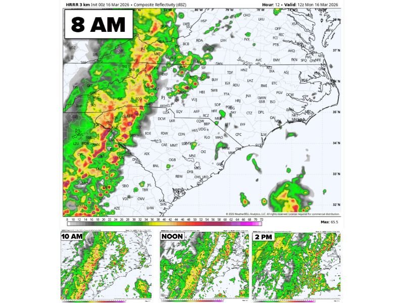
NORTH CAROLINA AND SOUTH CAROLINA — Forecasters are warning that a fast-moving line of severe storms could arrive earlier than expected Monday morning across parts of the Carolinas, bringing damaging winds and the possibility of isolated tornadoes as it sweeps east across the region.
Latest forecast updates late Sunday night indicate the main line of storms is accelerating slightly, which could push the severe weather threat into western parts of North Carolina earlier in the morning before moving toward central and eastern areas later in the day.
Meteorologists say the primary threat will be damaging wind gusts between 60 and 70 miles per hour, although isolated tornadoes cannot be ruled out within the strongest storms.
Storm Line Expected to Enter Western North Carolina Early
Weather models show the main line of thunderstorms approaching the mountain regions of North Carolina early Monday morning, potentially reaching western counties around or shortly before sunrise.
As the system pushes east, the line of storms is expected to intensify while moving toward the Piedmont and major cities such as Charlotte.
The storm line appears organized in a long squall line structure, which typically favors widespread damaging wind gusts as it travels quickly across the region.
Charlotte and Piedmont Areas Could See Morning Severe Weather
By the time the storms reach the Charlotte metro area, forecasters expect strong thunderstorms capable of producing severe wind gusts.
The most intense portions of the storm line could bring 60 to 70 mph winds, which are strong enough to knock down trees, cause scattered power outages, and damage roofs or outdoor structures.
Isolated tornadoes may also develop along the leading edge of the storm line where rotating pockets of wind form within the thunderstorms.
Meteorologists emphasize that tornadoes in these types of storm lines can develop quickly with little warning.
Storms Continue Toward Eastern North Carolina and South Carolina
After moving through the Charlotte region, the storms will continue east toward central North Carolina and eventually eastern parts of the state, while also impacting portions of northern South Carolina.
Communities across the Carolinas Midlands and coastal plain could experience strong thunderstorms later in the day as the system continues its eastward push.
Heavy rainfall, lightning, and gusty winds are expected to accompany the storms across much of the region.
Severe Weather Threat Expected to End by Late Afternoon
One positive aspect of the forecast is that the severe weather threat may move out of the Carolinas by late afternoon or early evening, as the storm line continues to weaken while pushing toward the Atlantic coast.
Once the line exits the region, conditions are expected to gradually improve across much of the Carolinas. However, forecasters caution that conditions could still change depending on the speed and intensity of the storm line, which remains under close monitoring overnight.
Residents Urged to Stay Alert Monday Morning
Because the storms may arrive during the early morning commute in parts of the Carolinas, officials are encouraging residents to stay alert for weather warnings and rapidly changing conditions.
Strong wind gusts can cause falling trees or power outages with little notice, and drivers should use caution if severe storms develop during travel hours.
Residents are encouraged to have multiple ways to receive weather alerts and to monitor local forecasts as the storm system approaches. Have severe weather impacts in your community Monday? Share updates with the newsroom and stay informed with continuing coverage at SaludaStandard-Sentinel.com.