North Carolina and South Carolina Severe Weather Threat Could Intensify Monday With Damaging Winds and Possible Tornadoes From Midlands to Coast
NORTH CAROLINA AND SOUTH CAROLINA — Forecasters are urging residents across the Carolinas to stay weather aware as a developing storm system could bring severe thunderstorms Sunday and Monday, with the highest risk currently expected across the eastern half of both states.
Meteorologists say not every community will experience severe storms, but the entire region could see rough weather as the system moves through. The greatest concern appears to be from the Midlands of South Carolina through eastern North Carolina and toward the coastal areas, where storms may arrive during the warmest and most unstable part of the day Monday.
Severe Storm Potential Across the Carolinas
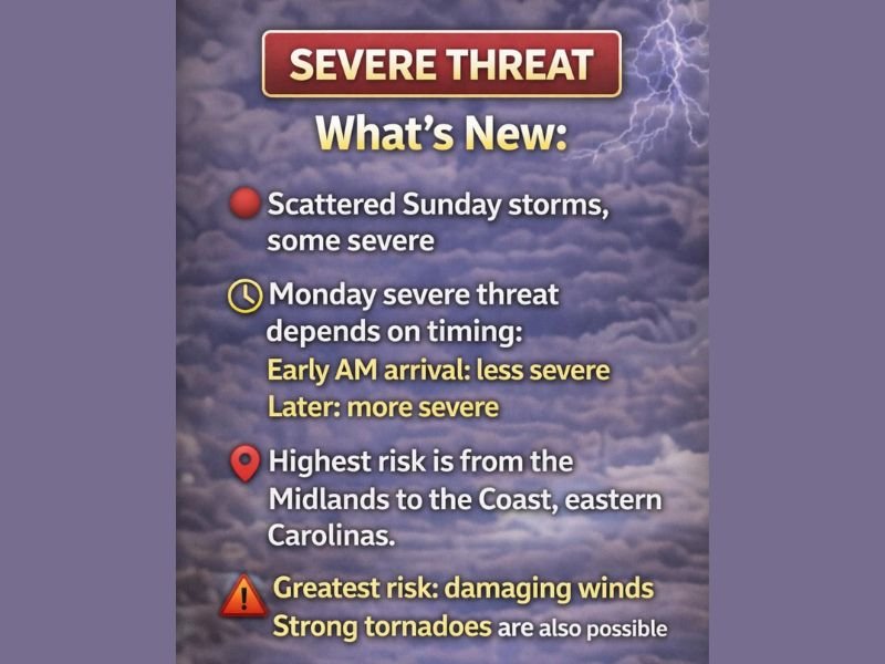
Weather experts say scattered thunderstorms are possible across the Carolinas on Sunday, with some storms capable of becoming severe. These early storms could bring heavy rain, lightning, and gusty winds to parts of the region. The larger concern arrives Monday when a stronger storm system moves through the Southeast.
Forecast guidance suggests that the timing of the storm system will play a critical role in determining how severe the storms become. If the system arrives early in the morning, the atmosphere may remain relatively stable, which could limit the severity of storms. However, if storms develop later in the day when temperatures rise and the atmosphere becomes more unstable, the severe weather risk could increase significantly.
Highest Risk Focused on Eastern Carolinas
At this time, meteorologists believe the highest risk zone stretches across the eastern half of the Carolinas, particularly from the South Carolina Midlands toward the North Carolina coastal plain.
Communities in these areas could experience stronger thunderstorms capable of producing damaging wind gusts and isolated tornadoes if atmospheric conditions become favorable. Storms that arrive during the afternoon or early evening hours could tap into warmer air and stronger instability, increasing the chances for severe weather development.
Damaging Winds Expected to Be the Main Threat
Forecasters say the most widespread hazard from this system is likely to be damaging straight-line winds, which can cause tree damage and power outages across affected communities. In addition to wind damage, some storms may produce tornadoes, especially if individual storm cells begin rotating within the larger system.
These tornadoes could develop quickly and with limited warning, which is why meteorologists are encouraging residents to monitor weather alerts closely. Heavy rain and frequent lightning may also accompany the strongest storms as they move across the region.
Western Carolinas May See Lower Severe Risk
While the entire region remains under a severe weather threat, the western Carolinas, including parts of the Upstate and mountain areas, may experience slightly lower severe potential.
Current projections suggest storms could arrive earlier in the morning across these areas when atmospheric instability may still be limited. Even so, forecasters stress that residents across western North Carolina and the South Carolina Upstate should remain alert because weather conditions can evolve quickly.
Residents Encouraged to Have a Plan
Meteorologists say storm systems like this can create anxiety because the exact timing and location of the most severe weather may not become clear until closer to the event. Emergency officials recommend taking time to prepare before storms arrive by identifying safe shelter locations and ensuring there are reliable ways to receive weather alerts.
Residents should consider where they will be when storms move through and where they can go if a warning is issued. Having multiple methods to receive warnings, including smartphone alerts and weather radios, can make a critical difference during severe weather events. As the storm system approaches, forecasters expect to refine the timing and locations most likely to see severe storms.
Readers across the Carolinas are encouraged to follow updates and share local weather conditions with the newsroom at SaludaStandard-Sentinel.com as the situation develops.