North Carolina and South Carolina Face High-Impact Sleet and Ice Storm Risk as GFS Data Signals Glacier-Like Road Conditions
CAROLINAS — New overnight data incorporated into the GFS weather model using hurricane hunter dropsonde observations is raising serious concern for a high-impact sleet-dominant winter storm across North Carolina and South Carolina, with freezing rain potentially falling on top of dense sleet accumulations. Meteorologists warn this setup is especially dangerous for roads and travel, even if power impacts remain more limited.
Sleet Dominates the Storm Profile Across the Carolinas
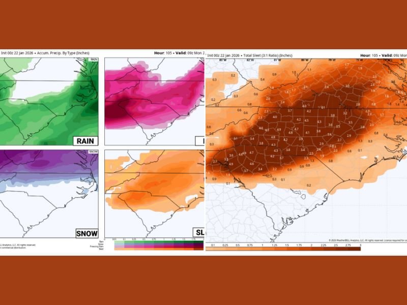
Unlike a typical snowstorm, the latest model guidance shows widespread sleet as the primary precipitation type across large portions of both states. Sleet is extremely dense, made up of roughly 90% water, compared to snow which is about 90% air.
Because of that density:
- Sleet compacts quickly
- It melts far more slowly
- It creates an icy base that is difficult to treat
If freezing rain falls on top of this sleet layer, roads can quickly become glacier-like, even in areas that do not receive heavy snow totals.
Ice on Top of Sleet Creates Severe Travel Hazards
While sleet is often less damaging to power infrastructure than freezing rain, it is far worse for driving conditions. The combination shown in the data suggests:
- Extremely slick road surfaces
- Long-lasting ice even after precipitation ends
- Limited effectiveness of road salt and brine
Travel impacts could be severe, especially overnight and during early morning hours when temperatures remain locked below freezing.
Snow Zone Remains Secondary but Still Possible
Snow is still indicated on the northern and western edges of the system, but it is not the primary threat in this setup. Where snow does occur, it may transition quickly to sleet, further compounding accumulation issues rather than improving travel conditions.
This reinforces concerns that areas expecting “less snow” may actually face worse conditions due to ice and sleet dominance.
Forecast Uncertainty Remains High Over the Next 48 Hours
Forecasters stress that details are still evolving, particularly regarding:
- Exact placement of sleet vs. freezing rain corridors
- Timing of precipitation type changes
- Temperature profiles near the surface
However, confidence is increasing that a significant sleet and ice event is likely somewhere across North Carolina and South Carolina, not just a narrow corridor.
More refined sleet, snow, and ice accumulation maps are expected within the next 24 hours as higher-resolution guidance comes into focus.
Bottom Line: Roads Are the Primary Threat, Not Snow Totals
This is shaping up to be a high-impact winter storm for the Carolinas, driven less by snowfall totals and more by dangerous sleet and ice layering. Even modest precipitation amounts could result in widespread travel disruptions, especially if freezing rain develops on top of compacted sleet.
Residents across North Carolina and South Carolina should prepare for rapidly deteriorating road conditions, remain flexible with travel plans, and monitor updates closely as the forecast sharpens. Stay with SaludaStandard-Sentinel.com for continued, location-verified winter storm coverage as new data arrives.