North Carolina and South Carolina Face Bitter Cold as Offshore Storm Track Could Decide Weekend Winter Impact
NORTH CAROLINA AND SOUTH CAROLINA — Cold air is once again pouring into the Carolinas as the region heads toward another potentially high-impact winter weekend. Forecast data shows bitter Arctic air firmly in place across both North Carolina and South Carolina, while a powerful storm system is expected to develop offshore along the East Coast, setting up a high-stakes forecast scenario where small track changes could dramatically alter impacts.
Bitter Arctic Air Locks In Across the Carolinas
The first piece of the puzzle is already certain. Very cold air is entrenched across both North Carolina and South Carolina, with temperatures running well below seasonal averages. Forecast guidance suggests this weekend may bring the coldest air of the winter so far, regardless of whether snow ultimately develops.
Even if precipitation remains limited, residents should prepare for dangerously low wind chills, biting winds, and prolonged cold exposure risks, especially during overnight and early morning hours.
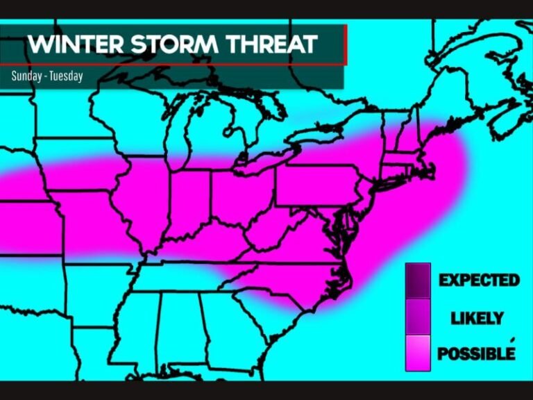
Offshore Storm Development Raises Winter Weather Stakes
At the same time, meteorologists are watching a strong storm system expected to form off the Carolina coastline. While confidence is increasing that a storm will develop, the exact track remains highly uncertain, and that uncertainty is driving the forecast complexity.
The storm’s path will determine whether the Carolinas see a messy winter mix, accumulating snow, or mainly dry but bitterly cold conditions.
Three Possible Tracks Remain on the Table
Forecasters currently outline three equally possible scenarios:
If the storm hugs the coast, North and South Carolina could experience a slushy winter mess, including rain, sleet, or wet snow with gusty winds.
If the storm tracks at just the right distance offshore — often referred to as the “Goldilocks” track — cold air and moisture would align, allowing snow to develop across parts of the Carolinas.
If the system stays too far offshore, the region would miss most precipitation, leaving dry conditions paired with intense cold and strong winds. At this stage, none of these outcomes can be ruled out.
Cold Impacts Possible Even Without Snow
Even in a low-snow scenario, impacts should not be underestimated. Bitter cold alone can strain power systems, stress infrastructure, and pose risks to pets, pipes, and vulnerable populations. Windy conditions may further increase cold stress and discomfort across the region.
Residents are encouraged to plan for extended cold exposure, review winter safety precautions, and remain flexible as forecast details become clearer.
What Happens Next
The next few days will be critical as forecasters monitor how the offshore system evolves. Subtle changes in timing or track could significantly shift impacts across North Carolina and South Carolina, making frequent forecast updates essential. Stay weather-aware, prepare for cold first, and be ready to adjust plans if winter weather develops.
What do you think — will the Carolinas catch snow, or will this weekend turn into another cold but dry setup? Share your thoughts and stay updated with the latest forecasts on SaludaStandard-Sentinel.com.