North Alabama Faces Expanded Friday Severe Weather Risk as Storm Prediction Center Broadens Outlook
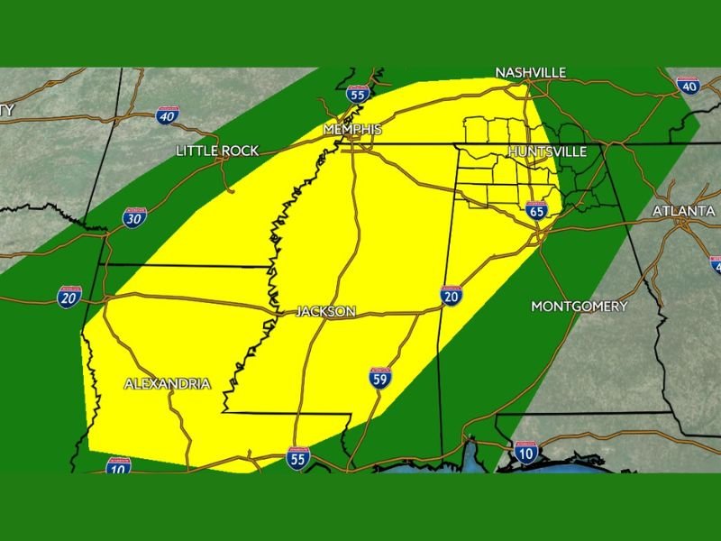
NORTH ALABAMA — The Storm Prediction Center (SPC) has expanded its severe weather outlook for Friday and Friday night, placing all of North Alabama within a broader risk zone as a slow-moving storm system brings multiple rounds of rain, thunderstorms, and gusty winds across the region. The updated outlook covers the period from 6 a.m. Friday through 6 a.m. Saturday, signaling a prolonged stretch of unsettled weather rather than a single, fast-moving event.
While meteorologists stress that this is not expected to be a widespread high-end severe outbreak, the expanded risk area reflects increasing confidence in an active weather pattern that could still produce localized impacts, especially after dark.
Expanded Risk Area Now Covers All of North Alabama
According to the latest update, North Alabama is now fully included in the SPC severe weather outlook, with the highest-risk zone extending westward from the Huntsville area into portions of the Lower Mississippi Valley. The broader risk zone also stretches across parts of Mississippi, Louisiana, and western Tennessee, indicating a large-scale system influencing much of the region.
The color-coded outlook places North Alabama primarily in a lower-tier severe risk category, meaning most storms will remain below severe limits. However, forecasters caution that stronger storms embedded within widespread rain could still produce isolated damaging wind gusts.
Friday Shaping Up as a Wet, Active Weather Day
Forecast guidance shows several rounds of rain and thunderstorms moving through the area throughout Friday. While there may be brief breaks in rainfall at times, weather officials advise against relying on dry windows for outdoor plans.
Rain totals are expected to exceed one inch in some areas by Friday afternoon, with additional rain continuing overnight into Saturday morning. By the time the system exits, total rainfall amounts of 2 to 3 inches are possible across parts of North Alabama, with locally higher totals in spots where storms repeatedly move over the same area.
Although widespread flooding is not expected, poor drainage locations and low-lying areas could experience temporary water issues, especially during heavier downpours.
Why Severe Weather Is Limited but Not Zero
During the daytime hours on Friday, severe weather looks unlikely for most of North Alabama. Heavy rain, thunder, and lightning are expected at times, but the lack of strong surface-based instability should keep storms from becoming intense.
After sunset, however, atmospheric conditions begin to change. Wind energy in the atmosphere increases, which could allow stronger storms to develop. One key limiting factor remains: low surface-based instability, which significantly reduces the likelihood of tornadoes.
That said, if a stronger storm does form, gusty winds are possible, especially within heavier rain bands. The combination of low instability and widespread rainfall will likely keep tornado potential low, but not entirely zero.
Overnight Rain and Storms Continue Into Saturday Morning
Storms are expected to persist well into Friday night and early Saturday, bringing additional rainfall before gradually tapering off. This extended duration is one reason forecasters are emphasizing preparedness, even though the overall severe threat remains limited.
Drivers should remain alert overnight, particularly in areas prone to ponding water or reduced visibility.
Bottom Line for North Alabama Residents
Friday will be wet, gray, and unsettled, with multiple rounds of rain and storms impacting the region. While widespread severe weather is not expected, the expanded outlook highlights the potential for isolated strong storms, gusty winds, and heavy rainfall, especially after dark. Flooding concerns remain localized, but residents should stay weather-aware throughout the day and night.
For continued weather updates, overnight alerts, and developing forecast changes across North Alabama and the Southeast, stay connected with SaludaStandard-Sentinel.com and share local conditions from your area with our newsroom.