New York, Pennsylvania, Virginia and New Jersey Headed Back to Below Normal Temperatures by Late April as Stubborn Winter Pattern Refuses to Let Spring Take Hold
MID-ATLANTIC AND NORTHEAST — Do not get too comfortable with the warmth arriving this week because the longer range forecast is delivering a cold and sobering reality check. Despite the warm-up expected over the coming days, the larger scale atmospheric pattern that dominated much of winter is poised to reassert itself across the Mid-Atlantic and Northeast as April closes out and early May approaches. The brief taste of spring warmth will not last, and forecasters warn this stubborn pattern is going to be very hard to kick.
Familiar Winter Pattern Returning to Dominate the East
The pattern behind this unwelcome return to cold is a well-established and persistent setup that has been in place for much of the winter. Ridging along the West Coast and troughing across the East creates a conveyor belt of cooler air that keeps the Mid-Atlantic and Northeast locked in a below-normal temperature regime.
As this pattern re-establishes itself heading toward late April and early May, daytime highs are expected to run several degrees below normal on a frequent basis. Nights will also turn chilly, particularly across inland areas where clearer skies and lighter winds allow temperatures to drop more efficiently during the overnight hours.
Brief Spring Warmth This Week Will Not Last
The warmth arriving this week is real but fleeting. Forecasters are clear that the upcoming warm temperatures do not represent a sustained pattern change and should not be mistaken for the arrival of consistent spring conditions. The eastern trough that is set to return will interrupt any prolonged warmth with additional cold fronts and reinforcing shots of cooler air that reset temperatures back below normal.
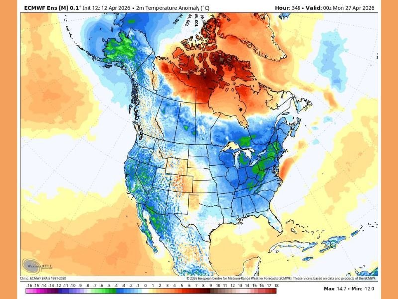
The ECMWF ensemble model valid through late April 2026 shows a broad area of below normal temperature anomalies blanketing the entire eastern United States, confirming what the longer range guidance has been signaling for several days.
Unsettled and Raw Conditions Also Possible Into May
Beyond the cold temperatures, this returning pattern will also bring an unsettled and at times raw feel to the region. A series of weak disturbances moving through the flow may produce intervals of clouds and scattered showers without delivering a prolonged washout for most areas.
Coastal locations across the Mid-Atlantic and Northeast could also experience periods of onshore flow, leading to damp and raw conditions with limited daytime warming even on days when rainfall is not occurring. The overall progression into consistent and comfortable spring warmth appears significantly delayed, with the atmosphere continuing to favor a cooler and more variable pattern well into May.
Residents should keep the layers handy for the weeks ahead. Stay weather aware and informed at SaludaStandard-Sentinel.com.