New York, New Jersey, Connecticut, Rhode Island, Massachusetts Blizzard Warning Spans 700+ Miles as Bomb Cyclone Brings 2 Feet of Snow and 75 MPH Gusts
UNITED STATES — Blizzard conditions are ongoing along a huge stretch of the East Coast as a powerful bomb cyclone spins off the Mid-Atlantic, producing near-zero visibility, dangerous drifting, and snowfall rates described as intense enough to make travel nearly impossible in some areas.
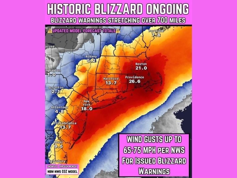
The latest update in the provided forecast notes over 700 miles of coastline now under a Blizzard Warning, with coastal wind gusts potentially reaching 65–75 mph and snowfall totals in hardest-hit corridors climbing toward 1–2 feet.
Blizzard Warning Coverage Expands Across Multiple Northeast States
Forecast imagery shows the heaviest band focused across parts of New York, New Jersey, Connecticut, Rhode Island, and Massachusetts, with significant impacts also extending toward Maine and into surrounding Mid-Atlantic zones.
The model-based totals displayed in the graphic highlight major-city impacts, including projected totals around New York City (about 18″), Boston (about 21″), and Providence (about 26″), with heavy snow also indicated near Hartford (about 13″) and Philadelphia (about 13″). While exact totals can shift during an ongoing storm, the displayed numbers point to a widespread, high-end event for the I-95 corridor and nearby coastal communities.
Snowfall Rates 2 to 4 Inches Per Hour Raise Whiteout Risk
The storm update warns of heavy snow falling at 2 to 4 inches per hour at times. That kind of intensity can overwhelm plowing efforts quickly and create rapid “whiteout” conditions, especially when combined with strong winds.
Visibility can drop to near zero in bursts, and roads that look merely snow-covered can become impassable fast as drifting builds over lanes and shoulders. Even short trips can turn dangerous when snowfall rates spike and emergency response times slow down.
Coastal Wind Gusts Up to 75 MPH Increase Outage and Damage Concerns
The same update calls out coastal wind gusts up to 75 mph, with widespread gust potential in the 65–75 mph range where Blizzard Warnings have been issued. Those winds can push snow into deep drifts, knock down limbs, and strain power lines—especially where snow is wetter and heavier closer to the coast.
Power outages were described as continuing to grow in the update, and the combination of strong winds plus heavy, clinging snow is often what turns a major snowstorm into a prolonged recovery event.
Travel Warnings Intensify as Conditions Become “Nearly Impossible”
The storm message included a clear warning that travel may be nearly impossible in the worst-hit areas, with conditions expected to remain hazardous as the blizzard continues. With heavy snow, high winds, and drifting, even well-treated roads can deteriorate rapidly.
If you must be outside, officials typically urge people to avoid unnecessary travel, keep phones charged, and have a backup plan if power goes out—especially in areas closer to the coast where wind is strongest.
Thundersnow Possible as the Storm Peaks
The update also notes that thundersnow is possible, a sign of intense upward motion inside the strongest snow bands. While not guaranteed everywhere, thundersnow can be a clue that the storm’s most dangerous core is overhead—often bringing the worst visibility and the fastest accumulation rates in a short time window.
If you’re in New York, New Jersey, Connecticut, Rhode Island, Massachusetts, or Maine, what are conditions like where you live right now—heavy snow, whiteouts, or power flickers? Share what you’re seeing and help others stay informed at SaludaStandard-Sentinel.com.