New York City Under First Blizzard Warning in 9 Years as Northeast Storm Triggers Warnings From Philadelphia to Boston
NEW YORK, NEW YORK — New York City has been placed under what forecasters are calling its first Blizzard Warning in nine years, as a strengthening winter storm pushes hazardous conditions up the I-95 corridor and into New England.
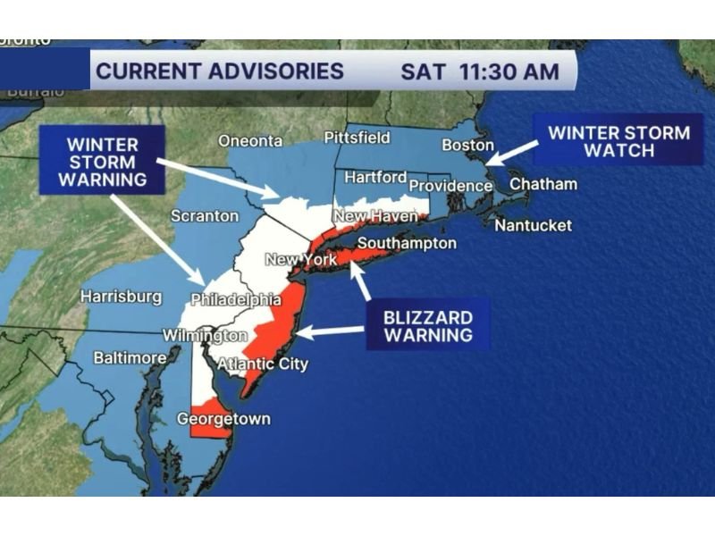
The latest advisory map (timestamped Saturday at 11:30 a.m.) shows a Blizzard Warning zone cutting through the New York City region and extending along portions of the coast, while surrounding areas face Winter Storm Warnings and Winter Storm Watches as the storm’s footprint expands.
Blizzard Warning Covers NYC and Nearby Coastal Areas
The Blizzard Warning area includes New York City and stretches into nearby coastal corridors, signaling the risk for whiteout visibility, blowing snow, and conditions that can become life-threatening if drivers get stranded.
Blizzard warnings typically reflect the combination of strong winds and heavy or blowing snow, where visibility can drop quickly and remain poor for extended periods. Even if snowfall totals vary neighborhood to neighborhood, the wind-driven impacts are often what make travel impossible.
Winter Storm Warnings Expand Across the Interstate 95 Corridor
Outside the blizzard zone, Winter Storm Warnings cover a broad region that includes parts of Pennsylvania, New Jersey, Delaware, and Connecticut, with major population centers such as Philadelphia and nearby communities in the warning area.
That warning footprint indicates a high confidence in significant snow and disruptive conditions, including slick roads, rapidly deteriorating visibility during heavier bands, and difficult commutes as temperatures remain cold enough for snow to accumulate quickly.
Winter Storm Watch Posted Near Boston and Coastal Massachusetts
Farther northeast, the map shows a Winter Storm Watch near Boston and across portions of coastal Massachusetts, including areas around Chatham and Nantucket.
A watch means conditions are favorable for a high-impact storm, and it often signals that warnings may be upgraded as the forecast becomes more certain. For travelers, that can mean last-minute changes to road conditions, public transportation disruptions, and shifting snowfall bands that can bring sudden bursts of dangerous weather.
What Residents Should Do Before Conditions Worsen
With multiple advisories posted at once, residents across the affected states are being urged to take common-sense steps before the worst arrives: finish errands early, charge phones and backup batteries, check medications, and avoid unnecessary driving once snow and wind ramp up. If you have family traveling through the region, it may be safest to delay plans until crews can fully clear roads.
If you’re in New York, New Jersey, Pennsylvania, Connecticut, Rhode Island, or Massachusetts, what are you seeing in your area—store rush, early closures, or roads already turning slick? Share your updates and storm photos with SaludaStandard-Sentinel.com to help others stay informed.