New York Buried by Historic Lake-Effect Snow as Upstate Communities See Up to Six Feet in Just Three Days
NEW YORK — Parts of upstate New York are experiencing one of the most intense lake-effect snow events in recent memory, with snowfall totals reaching as high as six feet in just three days in some communities. The extreme winter pattern has produced snowfall rates of up to seven inches per hour, creating whiteout conditions and dramatic contrasts between nearby towns.
The storm has been highly localized, with some areas seeing several feet of snow while locations just five miles away receive only a light dusting. This sharp difference is a hallmark of lake-effect snow, which forms when cold air moves across warmer water, generating narrow but powerful bands of snowfall.
Lake-Effect Bands Creating Extreme and Uneven Snowfall
Meteorologists describe this event as classic lake-effect snow, where intense snow bands behave like “firehoses,” dumping enormous amounts of snow in tight corridors. These bands can remain nearly stationary, allowing snow to pile up rapidly in one place while sparing neighboring areas.
Residents familiar with lake-effect events say the snow can arrive suddenly, forming what feels like a solid wall of snow with near-zero visibility. Travel during these conditions becomes extremely dangerous, as visibility can drop almost instantly with little warning.
Tug Hill Plateau Once Again Living Up to Its Reputation
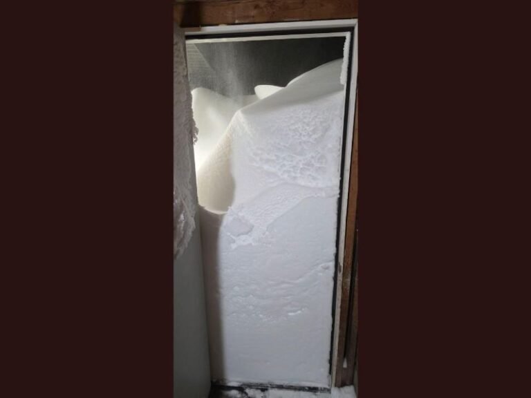
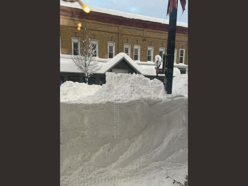
The photo shared from Pulaski, New York, located roughly 30 miles north of Syracuse, highlights the severity of snowfall in the Tug Hill Plateau, one of the snowiest regions in the United States. The area averages around 25 feet of snow annually, making it no stranger to extreme winter weather.
Pulaski sits squarely within the lake-effect snow belt, and the towering snowbanks captured in the image reflect how quickly accumulation has occurred during this event. Buildings, sidewalks, and roads are nearly swallowed by snow, underscoring the scale of the storm.
Businesses Push Through Despite Extreme Conditions
Despite the overwhelming snowfall, local businesses remain resilient. Artie’s Hometown Diner in Pulaski, where the photo was taken, remains open for business, a testament to the region’s preparedness and snow-removal expertise.
Communities across upstate New York are accustomed to heavy snow, and crews work continuously to clear roads, parking lots, and walkways. Residents note that while the snowfall is extreme, the region’s infrastructure and experience help keep daily life moving, even under extraordinary conditions.
Why This Snowfall Stands Out
What makes this event particularly remarkable is both the intensity and the speed of accumulation. Six feet of snow in three days, combined with hourly snowfall rates that rival some of the strongest lake-effect storms on record, places this system among the most impactful winter events the region has seen in years.
As lake-effect snow continues to shape winter life across upstate New York, this storm serves as a powerful reminder of how quickly conditions can change and how dramatically weather can differ from one town to the next. Have you experienced extreme lake-effect snow in your area? Share your story and stay connected with ongoing winter weather coverage at SaludaStandard-Sentinel.com.