New Jersey and New York Coastline Braces for Hurricane-Like Nor’easter With 80 MPH Gusts and 18–30 Inches of Snow
UNITED STATES — A powerful, hurricane-like Nor’easter is being forecast to intensify off the Mid-Atlantic and Northeast coast late Sunday, bringing what some forecasters are calling historic blizzard conditions to the New Jersey coast and Long Island, New York, with the worst impacts expected late Sunday through Monday morning.
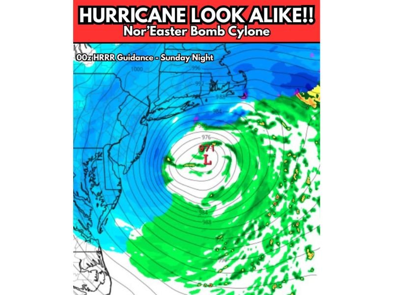
The latest model depiction shows an exceptionally deep coastal low—described as a Nor’easter “bomb cyclone”—with a tight pressure gradient capable of producing damaging wind gusts while heavy snow bands wrap inland.
Hurricane-Like Setup Along the Jersey Coast and Long Island
Forecast messaging for the storm highlights high to extreme impacts for coastal New Jersey and Long Island as the system strengthens offshore. Wind gusts in the 60–80 mph range are possible in the hardest-hit areas, which can create near-whiteout conditions when paired with intense snowfall and blowing snow.
Even where snowfall totals vary by town, the combination of strong wind and rapid accumulation can turn roads hazardous quickly, especially on bridges, parkways, and exposed coastal routes.
Snowfall Totals Could Reach 18–30 Inches in the Core Blizzard Zone
The storm’s most intense snow banding is projected to set up near and north of the low’s track, with 18–30 inches of snow possible in the most impacted corridor. If those totals verify, snow removal could be overwhelmed for a time, and travel may become extremely dangerous during the overnight peak.
This is the type of storm where conditions can deteriorate fast—one heavier band can drop visibility to near zero, while drifting piles snow back onto treated roads.
“Stadium Effect” Eye Feature Could Bring Sudden Lulls Then Another Surge
One unusual detail being discussed is the potential for a “stadium effect,” where a pocket of drier air forms near the center of the storm. That can create a deceptive lull—lighter precipitation or even a break—before heavy snow and wind roar back on the backside of the circulation.
Forecasters stress that despite the hurricane-like appearance on maps, this is a non-tropical system driven by winter storm dynamics.
Timing: Late Sunday Into Monday Morning Looks Most Dangerous
Storm impacts are expected to ramp up late Sunday, with the worst conditions overnight into Monday morning. That window is typically when snowfall rates, wind gusts, and drifting are most likely to peak—making it the most dangerous time to be on the roads.
If you have family or friends in New Jersey or New York, what are they seeing right now—stocked shelves, travel cancellations, or early closures? Share your updates and storm photos with us at SaludaStandard-Sentinel.com.