New England States — Maine, New Hampshire, Vermont, and Massachusetts Brace for a Two-Part Snow Event Tuesday Into Wednesday
NEW ENGLAND — A long-duration, two-part winter system is expected to bring elevation-dependent snowfall across Maine, New Hampshire, Vermont, and parts of Massachusetts from Tuesday into Wednesday, with forecasters warning that timing and amounts will vary significantly by location.
Snowfall Spread Will Vary as Two Distinct Waves Move Through
Meteorologists say this storm is proving challenging because it will arrive in two phases. Once the first wave ends in one area, snow is expected to redevelop in another, leading to a staggered precipitation pattern across the region.
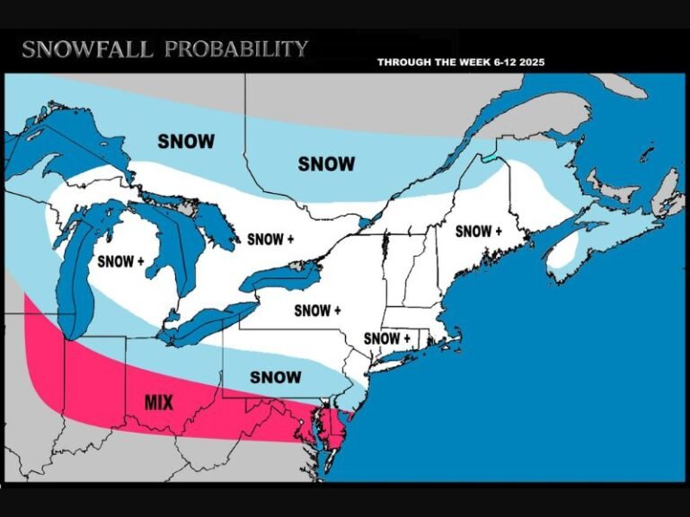
The most favorable corridor for accumulating snow runs from Old Orchard Beach, Maine, up through the White Mountains of New Hampshire, then northeast toward Monson and Bar Harbor, Maine. Outside these higher-elevation zones, accumulation is far less certain.
Forecasters estimate that much of the region will see 2–4 inches on average, though elevations will play a major role due to warm air lingering at lower levels during portions of the event. This could limit totals in southern New England and coastal areas.
Wind Expected on the Back Side of the System
The second half of Wednesday’s setup is expected to include gusty winds, particularly across interior Maine and northern New Hampshire. While not a major windstorm, narrowing visibility and blowing snowfall are possible during the latter stages.
Snow Map Indicates Highest Totals in Northern Zones
Updated accumulation projections indicate:
- 6–8+ inches possible in northern New Hampshire and interior Maine
- 4–6 inches across central New Hampshire and western Maine
- 2–4 inches for a wide stretch from southern Maine to central Vermont
- Trace to 1 inch for southern Massachusetts and Connecticut
These amounts remain subject to revision if temperatures fluctuate or either wave intensifies unexpectedly.
Additional Storm Systems Already on the Horizon
Meteorologists also warn that another system Friday into Saturday is likely to bring all snow to the northern half of New England, with southern areas seeing a rain–snow divide. A second disturbance Sunday night into Monday may again feature snow north and rain south, continuing an active early-winter pattern.
Forecast Updates Will Continue as Radar Trends Develop
Forecasters say that unless a significant overnight shift develops, the next detailed update will come once morning radar provides clearer insight into timing and band placement. For the latest regional weather updates throughout the week, visit SaludaStandard-Sentinel.com.