New England Faces Two-Part Winter Storm System Bringing Light Snow, Mixed Precipitation, and Midweek Clearing
MASSACHUSETTS — A pair of fast-moving winter systems will bring several rounds of snow, mixed precipitation, and briefly unsettled weather across New England from Monday through Tuesday night, before conditions improve midweek. While totals are expected to stay on the lighter side for most communities, timing and temperature differences will make the event highly location-dependent.
Monday: Winter Returns With Cold Temperatures
Monday marks the full return of winter conditions across the region. Morning temperatures will fall into the single digits and teens, with southern New England starting the day in the 20s.
Northern Vermont may see scattered morning snow flurries, while increasing cloud cover spreads across the region later in the day. No significant accumulation is expected Monday, but the cold sets the stage for Tuesday’s more active weather.
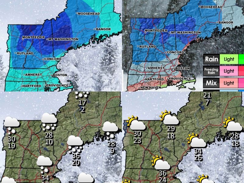
Tuesday Morning: First System Brings Light Snow From the Southwest
The first of two waves arrives early Tuesday, moving in from the southwest. Snow is expected to begin in southern New England around 7 a.m., spreading east and northeast through the morning and into the early afternoon.
• Snowfall is expected to remain light
• Rain and mixed precipitation will develop along the coast, Cape, and Islands
• Precipitation gradually tapers in southern areas during the afternoon
By midday, the first system weakens while the second one approaches from the opposite direction.
Tuesday Evening: Second System Moves In From the Northwest
Around 7 p.m. Tuesday, a stronger northwest disturbance arrives, bringing another round of snow — mainly to northern Massachusetts, southern New Hampshire, and into Maine.
Snow that had tapered earlier in the day will fill back in overnight, producing an additional period of accumulation that lasts into Wednesday morning. The second system exits the region by 10 a.m. Wednesday, ending the prolonged stretch of unsettled weather.
Wednesday: Clearing Skies and Milder Late-December Weather
Wednesday brings a welcome change. Skies turn mostly sunny, temperatures improve for late December, and quiet weather dominates most of the day.
Some pockets of light wind are possible Wednesday evening and overnight, but overall conditions will be calm compared to Tuesday’s activity.
Christmas Day: Mostly Sunny South, Snow Showers North
Christmas Day will feature very different weather depending on location:
• Northern New England: Organized snow showers are likely
• Southern New England: Mostly sunny skies
• Temperatures: Warmer-than-normal for late December
Travel conditions should be manageable for most of the region, with no major storm system expected on December 25.
What to Expect Overall
• Two separate systems
• Light snow totals for most areas
• Timing more impactful than accumulation
• Coastal mixing could limit snowfall
• A clean break midweek before Christmas
New England residents should plan for slippery roads at times Tuesday, but widespread significant snowfall is not expected. Stay informed with updated forecasts, and follow SaludaStandard-Sentinel.com for continuing coverage of weather impacting your region. For more breaking weather updates and regional reports, visit SaludaStandard-Sentinel.com.