Nebraska Winter Burst Brings Blowing Snow and 70 MPH Winds as Omaha and Lincoln Brace for Short but Intense Storm
NEBRASKA — A fast-moving winter storm is expected to sweep across parts of the state, bringing several inches of snow along with powerful winds that could create dangerous travel conditions across eastern Nebraska.
Forecast models indicate that the cities of Omaha and Lincoln could see measurable snowfall during a relatively short but intense window on the day the system passes through. While totals are not expected to be extreme, the combination of snow and strong winds could produce blowing snow and rapidly changing conditions.
Snowfall Forecast for Omaha and Lincoln
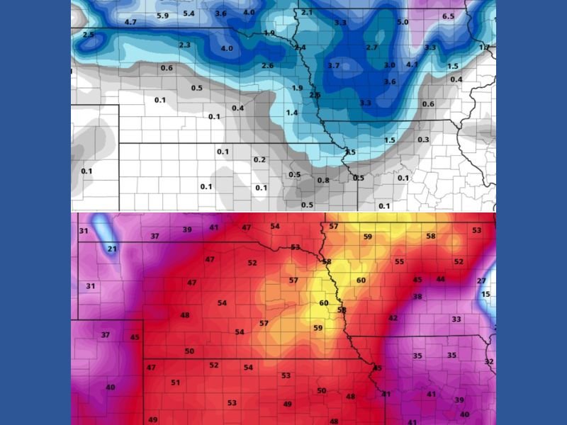
Weather models suggest Omaha could receive around 2.5 inches of snow, while Lincoln may see roughly 1.4 inches from the system. Some meteorologists estimate slightly higher totals, with projections ranging from 2.5 to 3 inches in Omaha and 1.5 to 2 inches in Lincoln depending on how the storm evolves.
The snow is expected to fall during a relatively narrow window, with forecasts suggesting precipitation could last about six hours, mainly from around noon through early evening. Because of the short duration of the storm, snowfall accumulation may occur quickly in bursts rather than through steady precipitation lasting all day.
Powerful Winds Could Create Blowing Snow
One of the most significant concerns with the approaching system is the wind. Meteorologists warn that wind gusts could reach at least 60 miles per hour, with some locations potentially experiencing gusts approaching 70 miles per hour.
These strong winds could cause blowing and drifting snow across roads and open areas, reducing visibility and making travel difficult even if overall snowfall totals remain moderate. Drivers across eastern Nebraska may encounter rapidly changing conditions as winds lift freshly fallen snow into the air.
Snowfall Distribution Across the Region
Weather model projections show heavier snow bands concentrated across portions of Nebraska and neighboring states, with several areas expected to receive between 2 and 4 inches of snow.
Northern sections of Nebraska and parts of the Midwest could see locally higher amounts depending on where the storm’s most intense snow bands develop. Further south, snowfall amounts are expected to decrease quickly as warmer air limits accumulation.
Brief but Impactful Winter System
Although the storm is expected to be relatively short-lived, the timing of snowfall and strong winds could create a challenging combination.
Short bursts of snow paired with powerful wind gusts can produce near-whiteout conditions at times, especially in open rural areas where blowing snow is more common. Meteorologists say this type of fast-moving winter system can still create significant disruptions even if snowfall totals appear modest.
Travel Conditions Could Deteriorate Quickly
Residents across eastern Nebraska are encouraged to remain aware of changing weather conditions as the storm approaches. Blowing snow and strong winds may impact visibility on highways and rural roads, especially during the peak snowfall period.
Travelers are advised to monitor local forecasts and prepare for rapidly changing road conditions during the storm’s passage. If you experience significant winter weather in your community, share your photos and reports with other readers by visiting SaludaStandard-Sentinel.com.