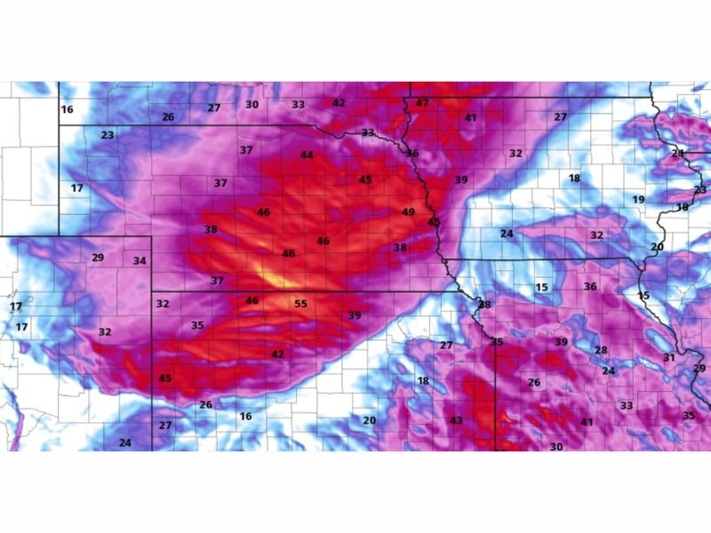
Nebraska, Kansas, South Dakota and Iowa Brace for 40 to 55 MPH Wind Gusts During Tuesday Morning Commute Before Conditions Ease
UNITED STATES — A powerful surge of gusty winds is expected to sweep across parts of the central Plains early Tuesday, with wind speeds exceeding 40 mph during the morning commute across Nebraska, Kansas, South Dakota, and Iowa.
Forecasters say the strongest winds will peak during the early hours of the day, creating potentially hazardous travel conditions before gradually weakening into the afternoon.
Strongest Wind Corridor Focused Across Central Plains
Weather models highlight a concentrated zone of intense winds stretching from western Kansas through central Nebraska and into parts of South Dakota and Iowa. Within this corridor, gusts could reach between 45 and 55 mph, especially in open areas.
This setup suggests a broad and organized wind event rather than isolated gusts, meaning large portions of these states could experience sustained periods of strong winds during the morning hours.
Morning Commute Likely to Be Most Impacted
The timing of this wind event is a key concern, as peak gusts are expected during the morning drive on Tuesday. Reduced vehicle control, especially for high-profile vehicles like trucks and SUVs, may create dangerous conditions on highways.
Blowing dust in rural areas and sudden crosswinds on exposed roads could further increase the risk for drivers traveling during the early part of the day.
Winds Gradually Diminish Into the Afternoon
As the system moves east and atmospheric conditions stabilize, wind speeds are expected to decrease steadily through the afternoon. While breezy conditions may linger, the most intense gusts should subside by midday or early afternoon. This easing trend will help improve travel conditions later in the day, though some areas may still experience occasional gusts.
Secondary Wind Zone Extends Into Midwest
Beyond the core Plains region, moderate wind gusts in the 25 to 40 mph range are expected to extend into parts of the Midwest, including Missouri, Illinois, and surrounding states.
While not as intense as the primary zone, these winds could still cause minor disruptions, especially in urban areas or where loose objects are not secured.
Residents Urged to Prepare for Wind Impacts
Officials advise residents to secure outdoor items, use caution while driving, and remain alert for rapidly changing conditions during the morning hours.
Even though this is not a severe storm setup, strong winds alone can cause damage and safety hazards, particularly when they arrive during peak travel times. Readers across the Plains and Midwest are encouraged to share conditions in their area or report impacts by visiting SaludaStandard-Sentinel.com.