National Weather Service Warns of Low Tornado Risk Across Northern Florida and Big Bend Region as Winter System Moves In
TALLAHASSEE, FL — Meteorologists are monitoring a developing weather setup that could bring isolated tornado activity to northern Florida and the Big Bend region on Tuesday, December 2, 2025, as the tail end of a winter system sparks scattered storms across the Southeast. While the threat remains low, forecasters stress that residents should remain alert for quick-forming severe weather.
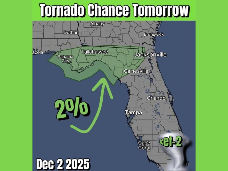
Slight Tornado Potential Across Northern Florida
Forecast maps show a 2% tornado probability zone stretching from Panama City and Tallahassee east toward Gainesville and Jacksonville, marking a small but notable risk area.
The National Weather Service says the setup could allow a “random tornado or two” to develop along the warm, unstable air feeding into the system’s southern flank.
Although conditions do not suggest a widespread outbreak, any brief spin-up tornadoes could still cause localized damage, especially in coastal or rural areas.
Meteorologists explain that the risk comes from the tail end of a larger winter storm system, which is currently influencing parts of the southern United States. As this system moves east, it could trigger isolated supercells capable of producing gusty winds, heavy rain, and a low-end tornado risk.
Timing and Areas of Concern
The highest risk period is expected to occur during the afternoon and early evening hours on Tuesday, particularly across the Florida Panhandle and the Big Bend corridor, including Tallahassee, Perry, and nearby communities.
By late evening, forecasters expect the storm line to weaken as it moves toward northeast Florida and into southern Georgia.
While the probability of tornadoes remains low, forecasters advise residents to review their severe weather plans and remain alert for any updates or warnings. Even a minor risk can produce significant effects when storms intensify rapidly in humid Gulf environments.
Residents Advised to Stay Weather-Aware
Weather experts recommend that residents in the affected areas keep phones charged, ensure weather alerts are enabled, and stay indoors during any thunderstorm warnings. Sudden wind gusts or brief tornadoes may develop quickly, offering little warning time.
Forecasters stress that this event represents a “low but notable risk,” meaning that while the majority of the area will not see tornadoes, the atmospheric setup does support isolated development that cannot be ignored.
Looking Ahead
Behind the front, cooler and drier air will move into northern Florida by midweek, ending storm chances and bringing more stable weather conditions. Temperatures are expected to dip into the 50s and 60s after the system clears the region.
Residents across the Florida Panhandle, Tallahassee, Gainesville, and Jacksonville are encouraged to follow the National Weather Service Tallahassee office and local emergency management pages for real-time alerts.
Have you experienced severe weather in northern Florida this year? Share your stories and preparedness tips with the Saluda Standard-Sentinel community at SaludaStandard-Sentinel.com.