Mississippi, Alabama, Tennessee, and Carolinas Could See Ice and Snow Early Next Week as Models Predict Southern Winter Storm
BIRMINGHAM, ALABAMA — Forecast models are pointing toward an unusual Southern winter setup early next week, showing the potential for ice and snow across parts of Mississippi, Alabama, Tennessee, the Carolinas, Arkansas, and Oklahoma.
While still several days away, forecasters warn that this developing system could cause dangerous travel conditions, power line stress, and icy roads across the Deep South — a region where even light wintry precipitation can bring cities to a standstill.
Early Models Show Widespread Ice and Snow Threat
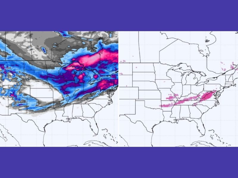
Both the European (EURO) and American (GFS) weather models show a potential for freezing rain and light snow accumulation from late Sunday through midweek.
The models highlight a corridor stretching from northern Mississippi and Alabama into Tennessee and the Carolinas, where temperatures near or below freezing could mix with incoming moisture. This combination may lead to glaze ice on bridges, elevated surfaces, and power lines.
Areas most likely to experience winter impacts include:
- Central and Northern Mississippi
- Northern and Central Alabama
- Western and Middle Tennessee
- Eastern Arkansas
- Northern Georgia
- Western and Central Carolinas
Meteorologists caution that while the maps may appear dramatic, even a fraction of an inch of ice is enough to cause major travel disruptions across the South.
Timing and Forecast Confidence
The current timeframe of concern is Monday, December 1 through Wednesday, December 3, when Arctic air meets Gulf moisture across the southern states.
If temperatures fall quickly enough, sleet and light snow could develop; otherwise, freezing rain will dominate — posing a more serious risk for power outages and tree damage.
“This is the type of setup where just a few degrees make all the difference,” forecasters explained. “Twenty miles north or south could determine whether you get a cold rain or an ice-covered neighborhood.”
Southern States Urged to Prepare
Officials urge residents across the region to prepare early and not underestimate the potential hazards. Power crews in several states are already on alert for the possibility of downed lines, while highway departments are preparing salt and brine treatments for major roads.
Expected impacts may include:
- Hazardous driving conditions and vehicle accidents
- Localized power outages in iced-over areas
- School and business closures in hardest-hit regions
- Flight delays across Southern airports
Because this event coincides with early December’s temperature drop, some areas could experience their first ice accumulation of the season.
Meteorologists Emphasize: This Is a Model, Not a Final Forecast
Experts stress that these projections are based on model guidance, which will likely evolve over the weekend. However, the consistency between models over multiple runs has increased confidence that some form of winter weather will impact the South.
“This isn’t a hype event,” said meteorologist Jason Huffman. “We’ve seen several signals now suggesting that a freezing rain and sleet event is increasingly possible early next week — especially from Mississippi through the Carolinas.”
Preparation Tips
Residents are advised to:
- Charge phones and backup batteries
- Stock up on essentials, including blankets and non-perishable food
- Avoid unnecessary driving once ice begins forming
- Stay informed through official National Weather Service updates
Outlook
If the model trends continue, next week could bring one of the most significant early-season winter weather events for the Deep South in recent years.
Communities from Jackson to Birmingham, Nashville to Charlotte could all be affected, depending on how the cold air and storm track align.
Stay tuned to SaludaStandard-Sentinel.com for the latest updates, advisories, and coverage as this potential Southern ice storm develops.