Mississippi Alabama Georgia and Tennessee Brace for Overnight Tornado Threat as TORCON 5 Signals Heightened Risk Across the Mid-South
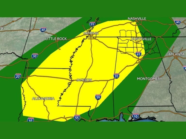
MISSISSIPPI — Meteorologists are warning of a heightened tornado threat across the Mid-South and Southeast as storm forecasters raise the TORCON index to level 5, signaling a medium risk of tornado development as a powerful storm system sweeps through the region Sunday evening and overnight.
The elevated risk zone stretches across parts of Mississippi, Alabama, Georgia, Tennessee, and surrounding states, where severe thunderstorms could produce tornadoes, damaging winds, and large hail late Sunday into early Monday morning.
Forecasters say the area with the highest potential for tornado development currently centers over northern Mississippi, with surrounding regions across the Deep South also facing elevated risks as storms move east overnight.
TORCON Index Raised as Severe Storms Organize
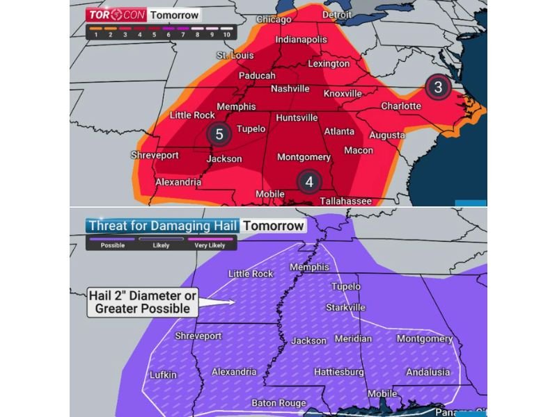
The TORCON index — a widely used forecast scale measuring tornado potential from 1 to 10 — was raised to 5 across parts of the Mid-South, indicating a meaningful chance of tornado formation as strong storms develop.
Areas surrounding that highest zone remain under TORCON 4 conditions, particularly across Alabama and Georgia, where storms are expected to intensify as they track east during the overnight hours. Meteorologists say atmospheric conditions appear favorable for rotating storms capable of producing tornadoes, especially as warm, unstable air collides with a strengthening storm front.
Large Hail the Size of Eggs Also Possible
In addition to tornado concerns, the storm system may bring damaging hail that could exceed 2 inches in diameter, roughly the size of a chicken egg.
Forecast maps show the greatest hail risk extending across portions of Louisiana, Mississippi, Arkansas, Alabama, and western Tennessee, where strong thunderstorm updrafts may allow hailstones to grow significantly before falling to the ground. Such large hail can cause damage to vehicles, roofs, and windows while also posing dangers to anyone caught outdoors during storms.
Evening Storm Timeline Across Major Cities
Storms are expected to develop across parts of the central United States Sunday evening before moving southeast overnight. Forecast timing indicates the following potential windows for severe weather:
Early Evening (Central U.S.):
- Chicago: 6 PM – 8 PM
- Champaign: 6 PM – 8 PM
- Grand Rapids: 7 PM – 9 PM
- Memphis: 6 PM – 8 PM
- Pine Bluff: 5 PM – 8 PM
- Paducah: 7 PM – 10 PM
Late Evening Into Overnight:
- Indianapolis: 9 PM – Midnight
- Nashville: 9 PM – Midnight
- Jackson, Mississippi: 9 PM – 11 PM
Overnight Into Early Morning:
- Louisville: 11 PM – 1 AM
- Birmingham: Midnight – 2 AM
- Montgomery: 3 AM – 6 AM
- Atlanta: 5 AM – 7 AM
- Cleveland, Ohio: 4 AM – 6 AM
Forecasters say storms are expected to shift eastward overnight, reaching much of Alabama and Georgia by the early morning hours Monday.
Southeastern States Urged to Stay Alert Overnight
Because many of the strongest storms may occur during the overnight hours, meteorologists are urging residents to ensure they have ways to receive weather alerts while sleeping.
Officials recommend enabling Wireless Emergency Alerts on mobile phones, keeping weather radios active, and monitoring local forecasts as conditions evolve. Nighttime tornadoes are often considered more dangerous because people may be asleep and less likely to receive warnings.
Severe Weather Pattern Part of Larger U.S. Storm Setup
The developing Mid-South tornado threat is part of a broader national weather pattern bringing severe conditions across several regions at once. Meteorologists say the same large-scale system is also contributing to damaging hail threats across the southern states, while other parts of the country are experiencing dramatically different weather conditions.
As the storm system continues tracking eastward, forecasters will be closely monitoring radar and atmospheric conditions to determine whether additional tornado watches or warnings become necessary.
Residents across the affected states are urged to stay informed and be prepared to move quickly if warnings are issued overnight. Stay with the Saluda Standard-Sentinel for continuing coverage and updates as severe weather develops across the region.