Minnesota, Wisconsin and Michigan See Strong Snow Season Totals While North Dakota and Northern Plains Fall Below Expectations Along I-90 Corridor
UNITED STATES — Seasonal snowfall trends are showing a clear divide across the northern United States, with parts of Minnesota, Wisconsin, and Michigan seeing strong totals while areas across North Dakota and the Northern Plains have significantly underperformed.
The latest data highlights how shifting storm tracks and atmospheric patterns have shaped a winter season that delivered heavy snow in some regions while leaving others well below average.
Heavy Snow Totals Concentrated Near Great Lakes
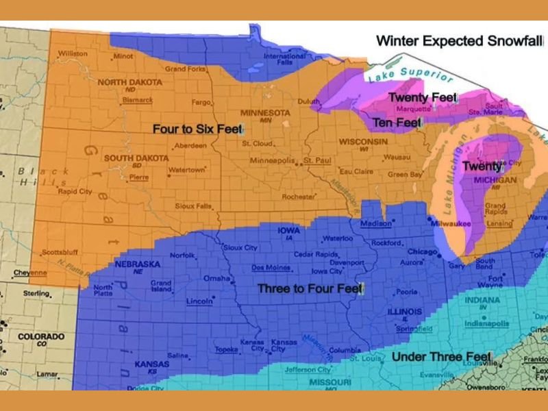
The most impressive snowfall totals have been observed across areas surrounding the Great Lakes, particularly in northern Wisconsin and Michigan. Some regions near Lake Superior and into the Upper Peninsula have recorded snowfall amounts reaching double-digit feet totals.
Localized areas have seen totals approaching or even exceeding twenty feet, driven largely by lake-effect snow and repeated storm systems tracking through the region. This consistent storm activity has helped boost seasonal snowfall totals well above average in these areas.
Minnesota Also Sees Strong Seasonal Snowfall
Much of Minnesota has also benefited from frequent winter systems, with widespread snowfall totals ranging from four to six feet across large portions of the state.
These totals reflect a steady pattern of storms moving through the region, contributing to a more active winter compared to areas farther west. Cities across the state have experienced multiple snowfall events, helping to build seasonal totals over time.
Northern Plains Struggle With Below Average Snowfall
In contrast, the Northern Plains—especially North Dakota—have seen significantly lower snowfall totals this season. The region has been influenced by a dominant northwest flow pattern that limited storm development and reduced moisture availability.
This pattern has resulted in well below average snowfall across parts of North Dakota and surrounding areas, marking a noticeable departure from typical winter conditions. The lack of consistent storm systems has been a key factor in the reduced totals.
I-90 Corridor Shows Clear Divide in Snowfall Trends
A notable dividing line appears along and north of the I-90 corridor, where snowfall totals increase significantly compared to areas farther south and west.
Regions along this corridor have seen more frequent storm impacts, while areas outside of it have experienced fewer opportunities for accumulating snow. This contrast highlights how storm track positioning can dramatically influence seasonal snowfall outcomes.
Midwest States See Mixed Snowfall Results
States such as Iowa, Illinois, Nebraska, and South Dakota have seen more moderate snowfall totals, generally ranging between three to four feet in many areas.
While not as extreme as the Great Lakes region, these totals still reflect a relatively active winter season compared to the Northern Plains. The variation across these states further emphasizes how localized weather patterns can shape winter outcomes.
Winter Pattern Highlights Importance of Storm Track Placement
This winter’s snowfall distribution underscores the critical role of storm track placement and atmospheric flow patterns. Areas positioned under consistent storm paths saw significant accumulation, while those outside those tracks missed out.
As the season transitions toward spring, these patterns provide insight into how future weather setups may behave. If you experienced above-average or below-average snowfall this winter, share your observations and totals with others by visiting SaludaStandard-Sentinel.com.