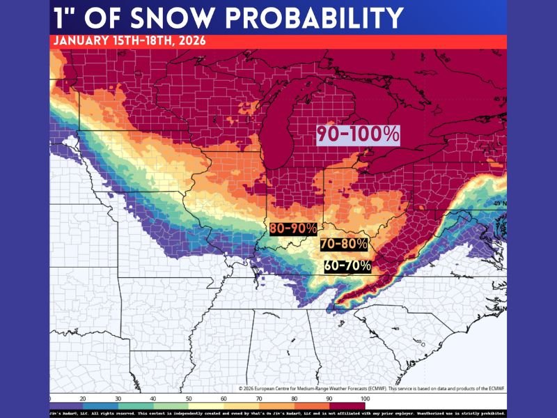
Midwest, Great Lakes, and Ohio Valley Face Elevated Snow Risk as Forecasts Show Widespread Chance for at Least One Inch Between January 15 and 18
UNITED STATES — Forecasters are signaling an elevated chance for measurable snowfall across large portions of the Midwest, Great Lakes, and Ohio Valley as the week progresses, with some areas showing a strong probability of receiving at least one inch of snow between January 15 and January 18. While officials stress the forecast is not locked in, confidence is increasing that winter weather will impact parts of the region before the end of the week.
Forecast Models Show Growing Snow Potential Late Week
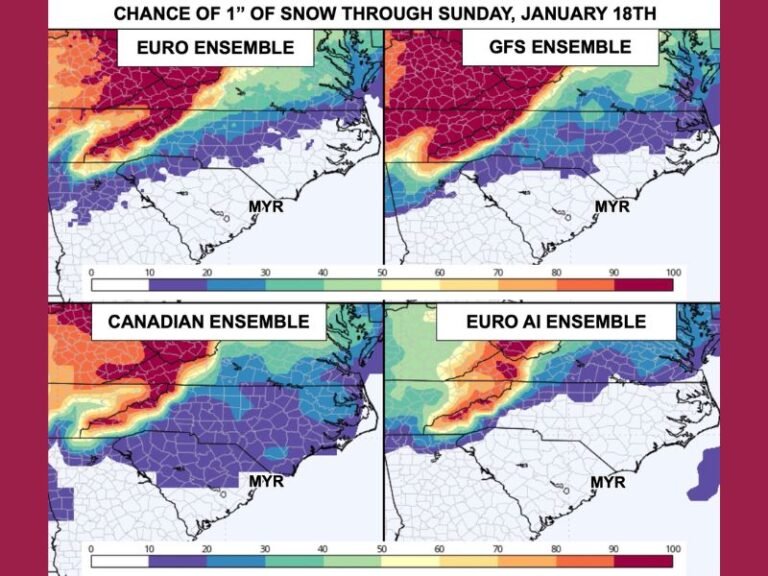
Recent guidance indicates a broad swath of the central and eastern United States could see accumulating snow as a winter system develops later in the week. Probability maps show high odds of at least one inch of snow, particularly across the Upper Midwest, Great Lakes region, and portions of the Ohio Valley. Meteorologists caution that not everyone will see snow, and exact placement will continue to shift as the event draws closer.
What the Probability Maps Are Indicating
Current projections show some areas with snow probabilities exceeding 80 to 90 percent, especially near and north of the Great Lakes. Farther south and east, probabilities taper but still suggest a meaningful chance for accumulation, especially if the storm track trends colder.
Forecasters emphasize that these maps reflect likelihood, not guaranteed totals, and should not be interpreted as final snowfall amounts.
Why Confidence Is Rising but Not Absolute
While long-range forecasts always carry uncertainty, meteorologists say key atmospheric signals are aligning in a way that supports winter precipitation. That said, small changes in temperature profiles or storm track could significantly alter outcomes, including switching snow to rain in some locations or shifting heavier snow bands north or south. This balance between growing confidence and lingering uncertainty is typical at this forecast range.
Big Snow Maps Circulating, But Timing Still Matters
Weather experts urge the public to be cautious about eye-catching snowfall maps circulating online, noting that many are based on early model runs and may exaggerate totals. The most reliable details will come closer to midweek, when higher-resolution data becomes available. At this stage, the key takeaway is potential, not precision.
What Residents Should Do Now
Residents across the Midwest, Great Lakes, and Ohio Valley are encouraged to monitor updates through the week, especially those with travel plans or outdoor work scheduled. While no immediate action is needed, staying informed will help communities prepare if confidence continues to increase.
Have you been tracking the snow chances in your area? Share your thoughts and follow continued winter weather coverage from SaludaStandard-Sentinel.com, where we break down developing forecasts with context and clarity.