Mid-February Warmup Takes Shape as Forecast Models Signal 80-Degree Potential in the South and a More Active Storm Track
UNITED STATES — A noticeable shift in the national weather pattern is coming into focus for mid-February, with forecast trends pointing toward warmer air spreading across much of the country and spring-like temperatures possible in parts of the South, according to emerging temperature guidance for February 10 through February 14.
While confidence remains higher in the warming trend than in specific storm placement, meteorologists say the overall setup suggests a more dynamic pattern compared to recent weeks.
Warm Air Expands Across Central and Eastern States
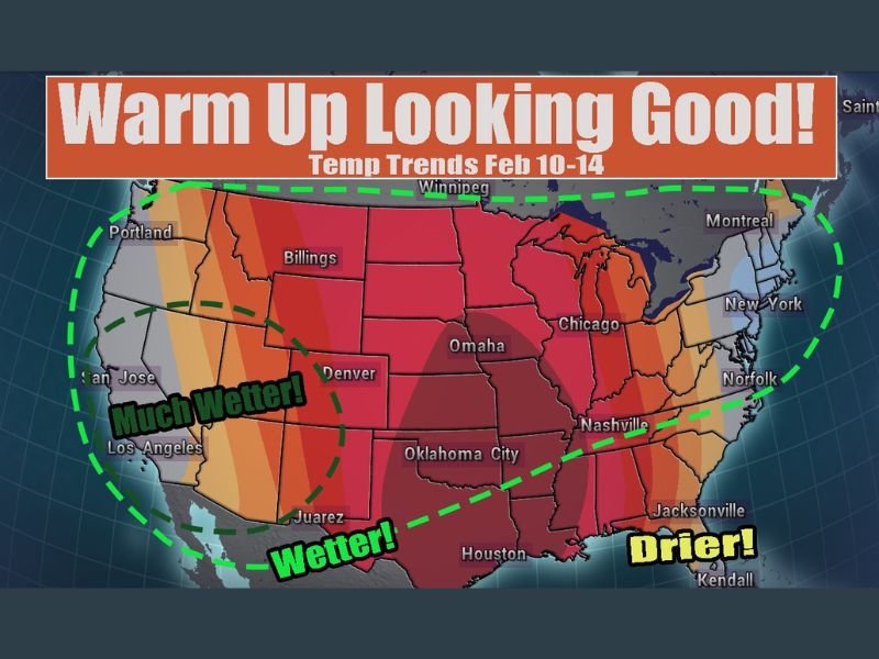
Temperature outlook maps indicate above-average warmth developing across the central and eastern United States, with the strongest anomalies centered from the Southern Plains through the Mississippi Valley and into the Southeast.
In some southern areas, high temperatures could climb into the 80s, an unusually warm reading for mid-February. Cities across Texas, Oklahoma, Louisiana, Mississippi, and neighboring states appear positioned beneath the warmest air mass as the pattern evolves.
The warmth is expected to build gradually rather than arrive abruptly, signaling a sustained mild stretch rather than a brief temperature spike.
West Coast Pattern Helps Drive Change
A key driver behind the warming trend is troughing along the West Coast, which typically allows warmer air to surge northward and eastward across the central part of the country.
This type of setup often favors milder conditions east of the Rockies, while also opening the door to a more active weather pattern downstream. However, guidance remains inconsistent on exactly how energetic the storm track will become.
Wetter Conditions Possible in the Southwest and Plains
Forecast graphics suggest wetter conditions developing across portions of the Southwest and central Plains, particularly from southern California through parts of the Southern Plains.
This aligns with the idea of Pacific systems tapping into moisture and tracking eastward, though the exact placement and intensity of rainfall remain uncertain at this stage.
Meteorologists caution that while the signal for increased moisture exists, pinpointing specific regions for heavy rain is difficult this far out, as model solutions continue to vary.
Southeast Likely to Trend Drier — For Now
In contrast, parts of the Southeast appear positioned on the drier side of the pattern, at least during the early phase of the warmup. That does not rule out storm chances entirely, but it suggests fewer widespread rain events compared to areas farther west.
As with all long-range forecasts, this detail is subject to change as models refine the timing and placement of weather systems.
Forecast Confidence: Strong on Warmth, Lower on Storm Details
Forecasters emphasize that confidence is highest in the temperature trend, not the storm specifics. The consistent signal across models supports the idea of a broad warmup, while precipitation and storm placement remain less certain.
As the February 10–14 window approaches, higher-resolution data will provide a clearer picture of who sees rain, storms, or simply warmer-than-normal conditions.
For continued updates on national and regional weather trends, including how this warmup could affect the Carolinas and Southeast, follow SaludaStandard-Sentinel.com as newer forecast data becomes available.