Mid-February Warm-Up Signal Strengthens Across the Southeast, Raising Hopes for a Milder Stretch in South Carolina
SOUTH CAROLINA — A fresh mid-month outlook is pointing to a stronger signal for milder weather across much of the Southeast, including South Carolina, as the forecast trend for Feb. 11–17 shifts noticeably warmer compared to what it suggested just days ago.
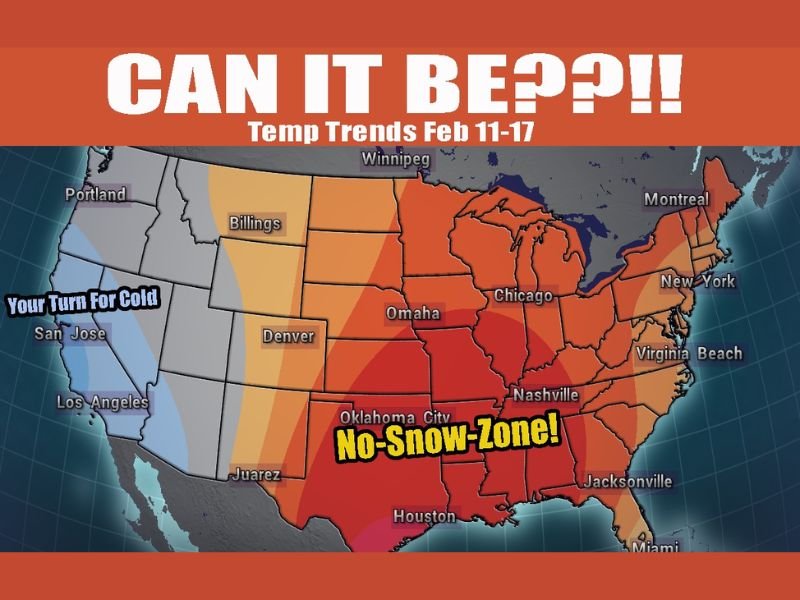
The updated temperature-trend map shows much of the central and eastern United States shaded in warmer colors, indicating above-average temperatures for the period, while the colder anomalies appear focused farther west. In plain terms: the Southeast’s odds of staying in a prolonged “deep-freeze pattern” look lower than they did earlier, and the region may get a legitimate break.
What the Feb. 11–17 Temperature Trend Suggests
The outlook highlights a broad zone of warmth stretching through the South and into parts of the Midwest and East. South Carolina sits on the warmer side of that overall pattern, suggesting a milder mid-February stretch is increasingly possible.
That doesn’t automatically mean shorts-and-sandals weather, but it does raise the likelihood of:
- Warmer daytime highs compared to early February
- Less frequent hard-freeze risk for many areas
- A reduced chance of widespread wintry precipitation if moisture systems move through
The update also emphasizes that this pattern “flipped” from colder expectations to milder expectations — a reminder that medium-range forecasts can change quickly as new data comes in.
What It Could Mean on the Ground in South Carolina
For South Carolina residents, a warmer mid-month trend matters because it can ease some of the biggest winter headaches:
- Icy bridge and overpass concerns may become less common if overnight lows stay higher
- Pipes and outdoor plumbing face less strain during milder nights
- School and commute disruptions become less likely without repeated freeze threats
It can also shift the primary weather focus away from winter hazards and more toward rainy systems and gusty fronts, which are typical when temperature swings increase.
Why Forecasters Are Cautious Even With a Warmer Signal
Even when a mild pattern looks more likely, one cold shot can still break through, especially during February. The forecast message behind this update also acknowledges uncertainty — the same reason the trend changed in the first place.
A warm-leaning pattern doesn’t guarantee every day will be warm, but it can mean the overall week favors milder air more often than not.
What to Watch Next
The most important next step will be whether day-to-day forecasts continue to support the warmer trend as the Feb. 11–17 window gets closer. If the mild signal holds, South Carolina may see a quieter stretch for winter weather — even if the season isn’t done taking swings yet.
What do you think — are you ready for a mid-February warm-up, or do you think winter has one more surprise left? Share your thoughts with us at SaludaStandard-Sentinel.com.