Michigan’s February 20 Weather Turns Messy: Stalling Low Brings Rotating Rain-Snow Bands and 45 mph Wind Gusts
MICHIGAN — Friday is shaping up to be a classic “everything at once” weather day across the state as a low pressure system moves in and then stalls over the region, keeping snow and mixed precipitation chances locked in for much of Michigan through the day.
Forecasters say multiple bands of precipitation will rotate through, which can make timing difficult. In practical terms, that means conditions may swing quickly from lighter precipitation to a heavier burst and back again, especially as the system continues to pivot across the Great Lakes.
Rotating Bands Keep the State Unsettled
The heaviest precipitation rates are expected in Northern Michigan, but a rain-snow mix may reach all the way down to the state line. Areas near the lakeshores and along typical transition zones could see on-and-off changes in precipitation type as temperatures shift during the day.
Some locations are flagged for mixed precipitation, including parts of Northern and Eastern Michigan, which could add slick spots where surface temperatures hover near freezing.
Temperatures Start Mild, Then Slip Through the Afternoon
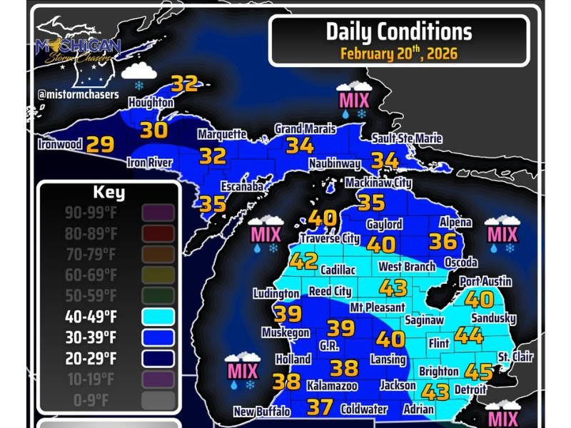
One of the more unusual parts of this setup is how temperatures evolve.
Southwest Michigan may start the day in the 40s, but readings are expected to drop into the 30s by afternoon as the low rotates and colder air filters in behind precipitation bands. The temperature map shows a broad range across the state:
- Upper Peninsula: upper 20s to mid-30s (around 29° at Ironwood, 32° near Houghton and Marquette, 35° near Escanaba)
- Northern Lower Michigan: mid-30s to around 40 (around 40° near Traverse City, 36° near Alpena)
- Southern Lower Michigan: upper 30s to mid-40s (around 39° near Grand Rapids, 38° Kalamazoo, 40° Lansing, 44° Flint, 45° Detroit)
Wind Advisory Focus South of I-96
Winds will be another major story. South of I-96, gusts could reach 45 mph, and wind direction may shift during the day as the low pressure circulation moves. Even where precipitation is lighter, strong gusts can reduce comfort and make driving more difficult—especially for high-profile vehicles.
Travel Note: The Farther North You Go, the Trickier It Gets
With heavier bands favored north and temperatures colder there, travel conditions are expected to be most challenging in Northern Michigan. Drivers should be prepared for fast-changing visibility and road conditions as rotating precipitation bands pass through.
For more regional weather updates and major-impact alerts across the U.S., keep following SaludaStandard-Sentinel.com and share what conditions look like in your area.