Michigan, Wisconsin, Indiana, and Ohio Face Additional Heavy Rain Threat Through Next Week With 1 to 4 Inches Increasing Flooding Concerns
MICHIGAN, WISCONSIN, INDIANA, OHIO — A new round of widespread rainfall is expected to impact the Great Lakes region through next week, with forecast models showing significant totals that could raise renewed concerns about flooding.
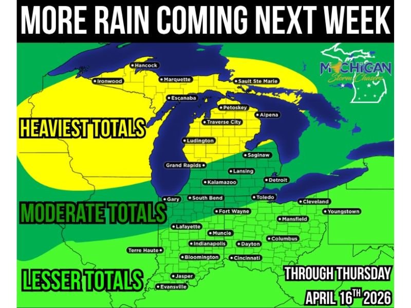
Early projections suggest much of Michigan could receive between 1 and 4 inches of rain from Sunday through Thursday, with the heaviest amounts focused across northern and western parts of the state.
Heavy Rainfall Totals Expected Across Michigan
Forecast data indicates that Michigan will be at the center of this developing rain event. Northern and western regions, including areas near Traverse City, Marquette, and Escanaba, are expected to see the highest totals.
These areas could receive up to 4 inches of rain in some locations, making them the primary zone for potential flooding concerns. Central parts of the state may also see moderate rainfall, while southern areas are expected to receive slightly lower totals.
Surrounding States Also See Moderate Rainfall
Beyond Michigan, surrounding states including Wisconsin, Indiana, and Ohio are also expected to see notable rainfall. While totals may not reach the same levels as northern Michigan, widespread rain is still expected.
Cities such as Indianapolis, Fort Wayne, Toledo, and Cleveland fall within zones projected to receive moderate rainfall amounts. This broader regional coverage increases the likelihood of multiple areas experiencing wet conditions simultaneously.
Flooding Concerns Begin to Increase
With multiple days of rain expected, concerns are growing about the potential for renewed flooding. Even if rainfall occurs in waves, the cumulative totals could lead to water buildup in low-lying areas.
Officials note that it is still too early to determine exact impacts for specific locations, but the trend is being closely monitored. Areas that have already received recent rainfall may be more vulnerable to additional runoff.
Forecast Subject to Change as System Develops
Meteorologists emphasize that this forecast is still evolving, and changes in storm track or intensity could shift where the heaviest rain falls.
Small adjustments in the system could significantly alter rainfall totals in certain areas. Residents are encouraged to stay updated as new data becomes available. Confidence in the general pattern is increasing, but finer details remain uncertain.
Wet Pattern Expected to Continue Through Midweek
The rain is expected to persist in waves from Sunday through Thursday, creating an extended period of unsettled weather across the region.
This prolonged pattern means that even moderate rainfall could accumulate over time, increasing the overall impact. Residents should be prepared for several days of wet conditions and possible travel disruptions.
If you are experiencing heavy rain or have concerns about flooding in your area, share your updates with us at SaludaStandard-Sentinel.com.