Michigan Winter Weather Alert: Travel Delays Could Spike Tuesday Night Into Wednesday, With Worst Conditions in the Upper Peninsula
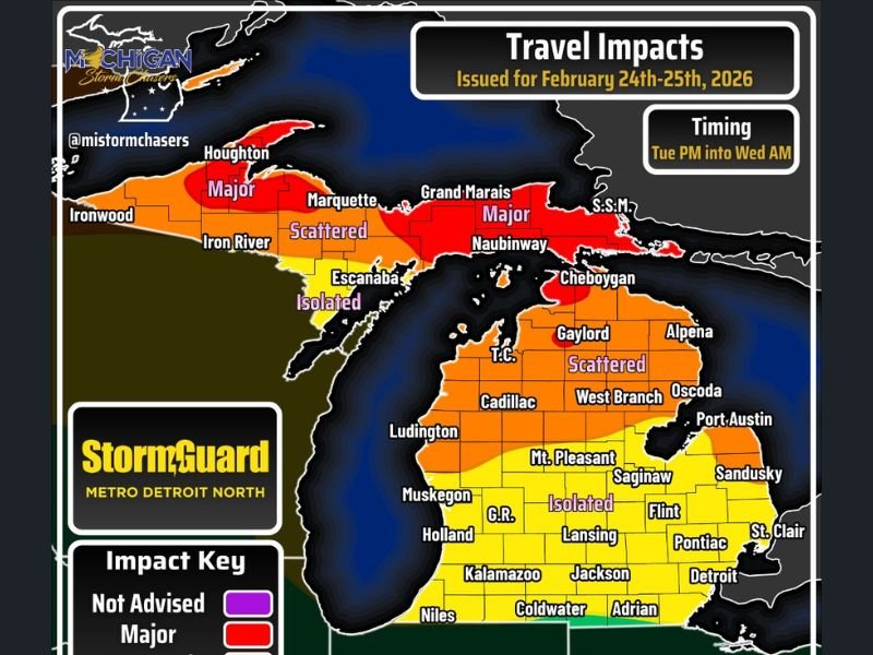
MICHIGAN — Roads across much of the state could turn slick and snow-covered late Tuesday into early Wednesday (Feb. 24–25, 2026), with forecasters warning that the greatest travel impacts will be north of US-10 and that snow totals near winter storm warning criteria are most likely in parts of the Upper Peninsula.
A travel-impact map issued for the Tuesday night window shows multiple zones across Michigan, ranging from very low issues in some areas to major travel disruptions in the far north. The worst conditions are expected Tuesday evening through Wednesday morning, and forecasters say school delays Wednesday would not be surprising in the hardest-hit areas.
Timing: When Conditions Are Expected to Turn Worse
The forecast focuses on Tuesday evening into Wednesday morning, when snow coverage and visibility problems could ramp up quickly. Even where totals stay modest, slushy roads and brief bursts of reduced visibility could slow commutes and early-morning travel.
Where Travel Is Most Likely to Be Hit Hardest in Michigan
The strongest impacts are highlighted across the Upper Peninsula, where the map marks major travel conditions in northern sections. That category signals multiple inches of snow, periods of difficult travel, and wind gusts over 40 mph that can blow snow across roads and cut visibility.
Across parts of the northern Lower Peninsula, conditions are shown as scattered impacts, meaning many back roads could become snow covered and main roads may pick up a coating of rain/snow mix. In that zone, weather-related travel delays may exceed 45 minutes, especially if snow bands linger.
Farther south in the Lower Peninsula—including several population centers—the map leans toward isolated impacts, which can still create headaches during peak travel times.
What Each Impact Zone Means for Drivers
Very Low Impacts
Snow totals generally under 0.5 inch. A few slick stretches are possible, but delays are expected to stay under 10 minutes.
Isolated Impacts
Snow showers with some rain mixing are possible. Totals generally 1–3 inches. A few visibility concerns may develop, with delays most often in the 15–35 minute range.
Scattered Impacts
Back roads may become widely snow covered, and more than half of main roads could see a light coating. Visibility may drop at times. Delays may exceed 45 minutes.
Major Impacts
Multiple inches of snow on main and back roads, travel discouraged unless absolutely necessary, and gusty winds that worsen drifting and visibility. Delays can exceed an hour in the worst periods.
What to Do Now Before Tuesday Night
Forecasters’ bottom line: plan for a snowy stretch late Tuesday, especially if your route takes you north of US-10 or into the Upper Peninsula. If you must travel, add extra time, slow down on untreated roads, and consider adjusting departure times to avoid the worst window Tuesday night.
If you’re in Michigan and seeing conditions change faster than expected Tuesday evening, we want to hear from you. Share what you’re seeing and where—then join the conversation at SaludaStandard-Sentinel.com.