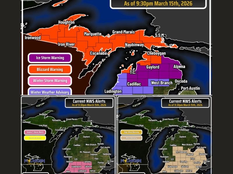
Michigan Weather Emergency: Blizzard, Ice Storm, Severe Thunderstorms and 50 MPH Winds Impact 80 of 83 Counties Overnight
MICHIGAN — A powerful storm system sweeping across the Great Lakes has placed 80 of Michigan’s 83 counties under some form of weather alert, creating one of the most widespread weather emergencies the state has seen this season.
As of late Sunday evening, meteorologists report that the state is simultaneously dealing with blizzard warnings, ice storm warnings, severe thunderstorm watches, wind advisories and winter weather alerts as the massive system continues moving across the region.
The unusual combination of weather hazards is impacting both the Upper Peninsula and Lower Peninsula with dramatically different conditions occurring at the same time.
Blizzard Warnings Continue Across the Upper Peninsula
The most dangerous winter conditions are unfolding across Michigan’s Upper Peninsula, where blizzard warnings remain in effect.
Heavy snow combined with strong winds is creating dangerous whiteout conditions and extremely poor visibility in areas including Houghton, Marquette, Escanaba and Iron River.
Officials say travel across the Upper Peninsula could become extremely hazardous, particularly during overnight hours as the storm intensifies.
Meteorologists warn that strong winds combined with blowing snow could lead to drifting snow and rapidly deteriorating road conditions.
Ice Storm Threat Expands Across Northern Lower Michigan
Meanwhile, parts of northern Lower Michigan are facing a significant ice storm threat.
Ice storm warnings covering counties including Emmet, Cheboygan, Charlevoix and Leelanau indicate that ice accumulation between a quarter inch and potentially up to a full inch could occur in some areas.
Ice accumulation of that magnitude can bring down tree branches and power lines, raising the possibility of extended power outages lasting multiple days.
Emergency officials warn that residents in affected areas should prepare for potential outages and dangerous travel conditions.
Lake Effect Snow Expected Along Lake Michigan Coast
Additional winter weather advisories are also in effect along much of the Lake Michigan shoreline, where lake-effect snow is expected to develop beginning Monday morning.
Cold air moving over the relatively warmer waters of Lake Michigan could produce localized snow bands that create rapidly changing road conditions along the coastline. Travel impacts from lake-effect snow are expected to begin around midday Monday and continue into the afternoon.
Severe Thunderstorm Watch and Strong Winds
Adding to the complex weather situation, parts of Michigan are also under a severe thunderstorm watch until 2:00 AM EDT, with the potential for thunderstorms capable of producing damaging winds between 60 and 70 miles per hour.
Although radar currently shows limited severe storm activity, meteorologists say conditions remain favorable for isolated storms capable of producing strong winds overnight.
Wind Advisories for Gusts Up to 50 MPH
Even outside of thunderstorms and winter precipitation areas, wind advisories remain in effect statewide. Gusts between 45 and 50 miles per hour are expected across large portions of Michigan through Monday.
These winds can bring down weakened tree branches, create blowing snow in northern regions, and make travel difficult across exposed roadways.
Travel Not Recommended in Parts of the State
Officials say travel is not recommended through early Tuesday for the Upper Peninsula and areas north of the M-55 corridor in the Lower Peninsula due to hazardous winter conditions.
Residents who must travel are urged to carry emergency supplies such as blankets, food, water, and winter survival gear in case they become stranded. Drivers are also encouraged to check road conditions before traveling as conditions may change rapidly during the storm.
Have severe weather impacts in your community? Share your experiences with the newsroom at SaludaStandard-Sentinel.com so readers across the region can stay informed as this complex storm system continues moving through Michigan.