Michigan Lake Effect Snow Bands Sweep Across Lower Peninsula Sunday, Creating Slick Roads and Travel Concerns Into Evening
MICHIGAN — A prolonged stretch of active weather across the state is ending with a final round of lake effect snow, expected to move through much of the Lower Peninsula on Sunday, April 5, 2026. Snow bands developing off Lake Michigan are forecast to persist through the morning and continue into the late afternoon, creating periods of reduced visibility and slick travel conditions.
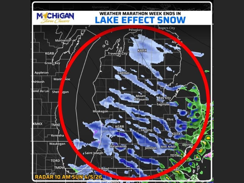
The system marks the closing phase of what has been described as a “weather marathon” week for Michigan, with multiple rounds of changing conditions leading up to this final event.
Lake Effect Snow Targets Multiple Regions Across Lower Peninsula
Radar imagery shows several narrow but persistent bands of lake effect snow stretching across western and central portions of the Lower Peninsula. Areas including Traverse City, Cadillac, Mount Pleasant, and Kalamazoo are expected to see intermittent bursts of snowfall as these bands shift eastward throughout the day.
As the system progresses, eastern sections of the state—including areas near Saginaw, Flint, and Ann Arbor—could experience increased snowfall activity later in the day. The timing suggests that snowfall may impact nearly the entire region at different points, depending on how the bands organize and drift inland.
Unlike widespread snowstorms, lake effect events tend to be more localized, meaning conditions can vary significantly over short distances. Some communities may see steady snow for hours, while others nearby experience only brief flurries.
Light Accumulations but Noticeable Travel Impact
While total snowfall amounts are not expected to be significant, forecasters indicate that even a thin coating of snow could be enough to create hazardous road conditions. Early April ground temperatures may limit accumulation in some spots, but colder surfaces—especially bridges and elevated roadways—could quickly become slick.
Drivers heading out Sunday morning, particularly those with holiday or weekend travel plans, are being urged to use caution. The combination of light snow and fluctuating visibility may lead to slower travel and potential delays across impacted regions.
Timing Extends Through Much of Sunday
The lake effect pattern is expected to begin early Sunday morning and persist through much of the day. Western areas will likely see activity first, with snow bands gradually shifting eastward as winds push moisture inland.
By late afternoon and early evening, conditions should begin to improve as the snow bands weaken and move out of the region. However, lingering slick spots on roadways may remain into the evening hours.
A Chilly End to an Active Weather Week
This event caps off a week of varied weather across Michigan, bringing a winter-like finish to the start of April. The presence of lake effect snow this late in the season highlights how quickly conditions can shift in the Great Lakes region, even as spring officially takes hold.
Residents are encouraged to stay alert to changing conditions throughout the day, especially when traveling between regions where snowfall intensity may differ.
If you’re experiencing changing conditions in your area, share your updates and photos with us at SaludaStandard-Sentinel.com and let others know what you’re seeing on the roads today.