Michigan and Wisconsin Face Re-Slick Roads Tonight as Snow and Freezing Drizzle Fade Near Midnight, With More Snow Expected Friday
MICHIGAN — Light snow and freezing drizzle continued across much of the state as of 4:45 p.m. EST, with most precipitation expected to taper off around midnight. Even where some main roads have started to clear, the bigger concern overnight is that temperatures dropping after dark could cause roads to re-slick, especially in untreated areas and on bridges.
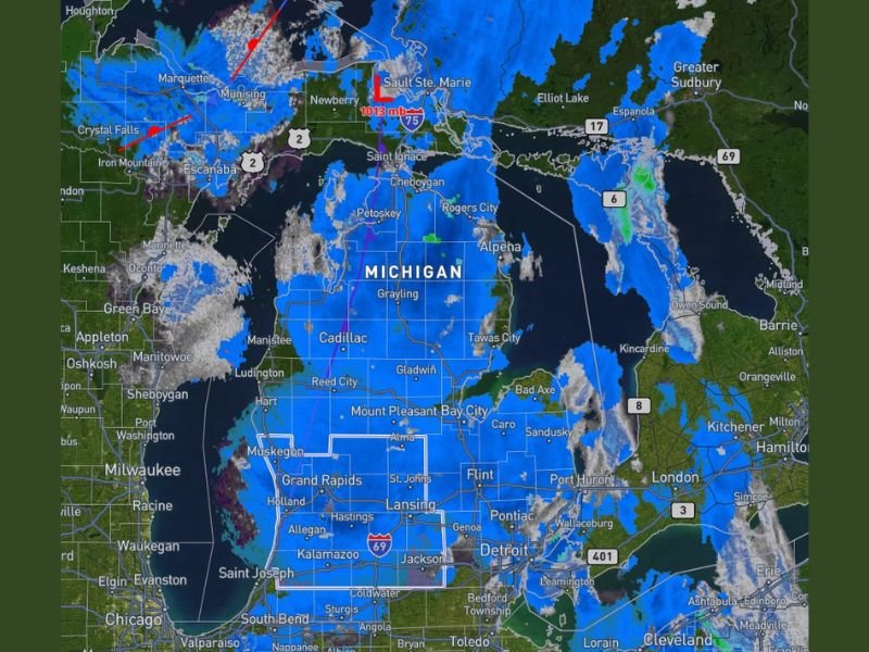
Radar Update Shows Widespread Light Winter Precip Across the State
The radar snapshot shows broad coverage of light wintry precipitation across Michigan, including stretches of the Lower Peninsula and areas near the Great Lakes shoreline. Bands of snow also appear near and around parts of northern Michigan, with additional activity visible across nearby parts of Wisconsin and into portions of Ontario.
This type of widespread, lighter precipitation can be deceptive: it doesn’t always look intense, but when freezing drizzle mixes in, it can create slick conditions quickly—particularly during the evening hours when visibility drops and surface temperatures cool.
Why Roads May Turn Slick Again After Dark
While some main roads may improve as precipitation eases, the forecast note emphasizes a common late-day problem: once night falls, any lingering moisture can refreeze, causing roads to become slick again even after conditions briefly improve.
Drivers are urged to be cautious in the areas most likely to ice first, including elevated surfaces like overpasses, ramps, and bridges, as well as shaded side streets and rural roads that may not receive the same level of treatment as major highways.
What “Wrap Up Around Midnight” Means for Travel
Most precipitation is expected to wrap up around midnight, which suggests the steadiest snow and drizzle should gradually diminish through the evening. However, the end of falling precipitation does not automatically mean the end of hazards. In many winter setups, the most dangerous window can come after the radar quiets down—when leftover moisture freezes on pavement and visibility remains limited.
For anyone traveling late tonight or early Wednesday morning, the key concern is not just what’s still falling, but what’s left behind on the road surface as temperatures drop.
More Snow Expected Friday, With Details Coming Soon
Another important piece of the update is what comes next: more snow is expected on Friday, and additional information about that next round is expected to be released over the next day or two.
That timing matters for commuters, schools, and anyone with end-of-week travel plans. Even if tonight’s precipitation ends quietly, a follow-up system later in the week can keep road crews and residents in winter mode—especially if Friday’s snow arrives during high-traffic hours.
What Residents Should Do Tonight
The practical message is simple: conditions may improve in spots, but don’t assume the threat is gone once the radar starts thinning out. If you’re heading out this evening, slow down on turns and ramps, leave extra distance, and be prepared for patches of slick pavement that redevelop after dark.
Have you seen roads improving where you are, or are they still icy and slushy? Share what you’re seeing in your area and follow continuing updates at SaludaStandard-Sentinel.com.