Mercer County Ohio Hail Emergency Near Celina as 20,000 Foot Storm Core Signals Golf Ball Size Hail Threat Thursday Night
OHIO — A dangerous hail-producing storm is intensifying in Mercer County Thursday evening, with meteorologists warning of a significant large hail threat south of Celina.
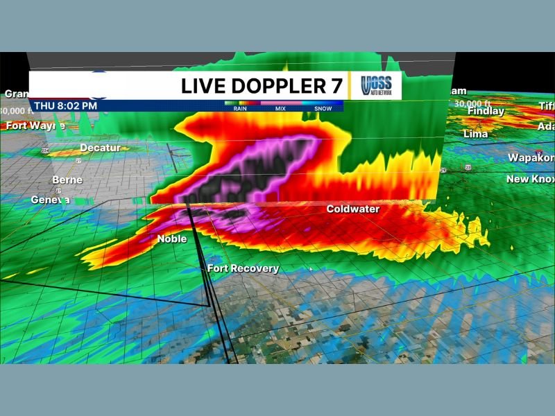
Radar and 3D storm imaging show a powerful hail core reaching nearly 20,000 feet into the atmosphere — a key indicator that the storm is capable of producing large, potentially damaging hailstones.
Storm Core Signals High-End Hail Potential
The storm’s vertical structure is raising serious concern among weather experts. A hail core extending to around 20,000 feet typically indicates strong updrafts, which allow hailstones to grow larger before falling to the ground.
In this case, forecasters say hail could reach golf ball size, posing a risk to vehicles, roofs, and anyone caught outside. The most intense portion of the storm is currently tracking near areas south of Celina, including communities around Coldwater and Fort Recovery.
Immediate Danger Zone Identified in Mercer County
Live Doppler radar imagery shows a dense and highly organized storm cell, with the most intense hail region highlighted by deep red and purple returns — a classic signature of large hail.
Communities in the storm’s direct path are being urged to take immediate precautions as conditions can deteriorate rapidly. The storm’s strength and structure suggest that hail could fall quickly and without much warning once it reaches the ground.
Residents Urged to Take Shelter Immediately
Officials are stressing urgency as the storm moves through the region. Residents near Celina and surrounding Mercer County areas are advised to move indoors immediately and avoid windows.
Vehicles should be moved into garages if possible, as hail of this size can easily cause damage. Even brief exposure to large hail can result in injuries, making it critical to stay sheltered until the storm passes.
Storm Continues Tracking Across Western Ohio
As of the latest update around 8:03 PM, the storm remains active and continues to move across western Ohio.
While not every location will see the largest hail, the presence of such a strong hail core means isolated areas could experience significant impacts. Weather conditions remain volatile, and additional warnings could be issued as the storm evolves.
Residents in Mercer County are encouraged to report conditions and stay updated as this storm moves through by visiting SaludaStandard-Sentinel.com.