Massive Rotating Supercell Thunderstorm Structure Explained as Rare Clear View Shows Inflow Bands and Mesocyclone Dynamics Across Open Plains
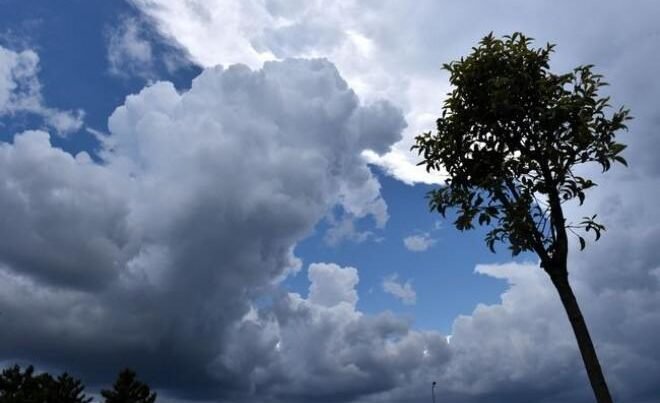
UNITED STATES — A rare and striking view of a fully developed supercell thunderstorm is offering a closer look at one of nature’s most powerful and complex weather systems. The image captures the defining features of a rotating storm, including strong inflow bands and a persistent mesocyclone, elements that are responsible for some of the most dangerous severe weather events in the country.
Supercells are not ordinary thunderstorms. They are highly organized systems driven by a rotating updraft, known as a mesocyclone, which allows them to sustain themselves for long periods while producing extreme weather conditions.
What Makes a Supercell Different From Other Storms
Unlike typical thunderstorms, a supercell must contain a persistent rotating updraft. This rotation is the key factor that separates it from weaker storm systems. While many storms may briefly show signs of spin, supercells maintain this rotation consistently, making them far more intense and dangerous.
The rotation helps the storm organize itself efficiently, allowing it to produce large hail, powerful straight-line winds, and potentially destructive tornadoes. Meteorologists often consider supercells to be the most dangerous type of thunderstorm due to their ability to sustain severe conditions over extended periods.
Understanding the Role of the Mesocyclone
At the heart of every supercell is the mesocyclone, a rotating column of air within the storm. This feature drives the storm’s structure and is responsible for its longevity and strength.
There is no strict rule for how long a storm must rotate to qualify as a supercell. However, when a mesocyclone becomes clearly visible, as seen in this case, it indicates a well-developed and potentially hazardous system. The persistence of this rotation is what allows the storm to intensify and organize into a powerful weather engine.
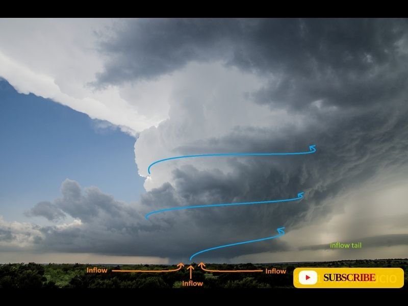
According to the visual analysis , the storm’s structure shows strong rotational flow and clearly defined inflow patterns feeding into the system, confirming the presence of a mature supercell.
Inflow Bands and the Storm’s Fuel Supply
One of the most noticeable features in the image is the inflow bands—streams of warm, moist air being drawn into the storm. These inflow currents act as fuel, feeding energy into the rotating updraft and sustaining the storm’s intensity.
The labeled arrows in the image highlight how air is being pulled into the system from multiple directions. This inflow is essential for maintaining the storm’s structure and can often be observed as layered, curved cloud bands leading into the main updraft.
As long as this inflow remains strong and uninterrupted, the supercell can continue producing severe weather, including heavy rainfall, hail, and strong winds.
Why Clear Views of Supercells Are Rare
Seeing the full structure of a supercell like this is uncommon. In many cases, low clouds, precipitation, or poor visibility obscure the storm’s internal dynamics. However, when conditions align, observers can witness the entire system in action.
This rare clarity provides valuable insight into how these storms function. The towering updraft, rotating core, and inflow structure all work together in a balanced system that meteorologists often describe as a “perfectly organized machine.”
These moments are not just visually dramatic—they also help researchers and forecasters better understand storm behavior and improve warning systems for communities in affected areas.
The Danger Behind the Beauty
While the image showcases the beauty and complexity of a supercell, it also serves as a reminder of the risks associated with these storms. Supercells are responsible for some of the most destructive weather events, including large tornado outbreaks and widespread damage from hail and winds.
Understanding their structure is crucial for forecasting and public safety. The more clearly these systems can be identified, the better prepared communities can be when severe weather develops.
The powerful rotation and inflow seen in this case highlight just how quickly conditions can escalate when a supercell forms. As severe weather season continues across parts of the United States, recognizing these features can make a critical difference in staying safe.
Have you ever witnessed a supercell or experienced severe storm conditions in your area? Share your story or observations with us at SaludaStandard-Sentinel.com and join the conversation.