Massive Rotating Supercell East of Enid Oklahoma Produces Dangerous Storm Structure as Severe Weather Threat Intensifies Across Region
OKLAHOMA — A powerful severe thunderstorm east of Enid produced a striking and potentially dangerous storm structure, signaling an intensifying severe weather threat across parts of northern Oklahoma.
The storm, already under a severe thunderstorm warning at the time, displayed strong rotation and a well-defined structure often associated with supercells capable of producing large hail, damaging winds, and even tornadoes.
Highly Organized Storm Structure Observed East of Enid
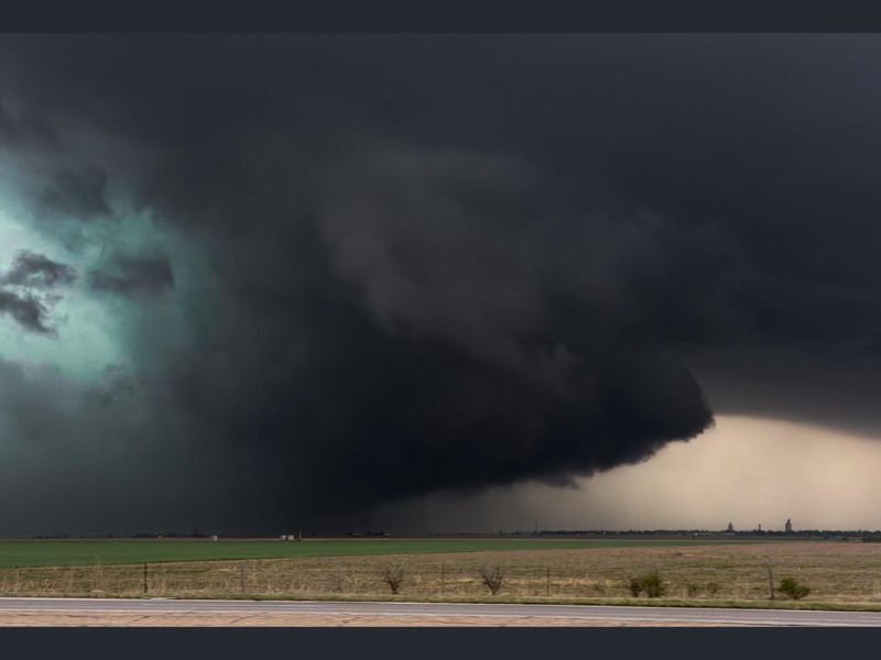
Images from the storm show a classic supercell formation, with a large, rotating base dominating the sky over open farmland. The structure appears lowered and organized, a key indicator of strong updrafts and rotation within the storm.
This type of storm structure is often described as “textbook” by weather observers and can be a precursor to more dangerous developments, including wall clouds or tornado formation if conditions continue to support rotation.
Severe Thunderstorm Warning Already in Effect
At the time the structure was observed, the storm was already under a severe thunderstorm warning, confirming that hazardous conditions were either ongoing or imminent.
Severe storms in this region are known for producing large hail and damaging wind gusts, both of which can cause significant damage in a short period of time. The presence of strong rotation further raises concern for additional escalation.
Environment Favoring Supercell Development Across Oklahoma
Northern and central Oklahoma have been under conditions favorable for severe weather, including instability, wind shear, and sufficient moisture — all key ingredients for supercell thunderstorms.
Storms developing in this environment have the potential to remain organized for extended periods, increasing both their intensity and lifespan as they move across the region.
Why This Storm Structure Matters
The visual appearance of a storm can provide critical clues about its strength and potential hazards. A large, rotating base like the one seen east of Enid suggests a powerful updraft and organized storm dynamics. While not every rotating storm produces a tornado, these types of structures are often closely monitored because they can evolve rapidly.
Residents Urged to Stay Weather-Aware
With storms already showing signs of strong organization, residents across northern Oklahoma are urged to remain alert and ready to take action if warnings are issued.
Severe weather can escalate quickly, especially with supercell thunderstorms, making it essential to monitor updates and have a safety plan in place. Have you seen severe weather conditions in your area? Share your experience and stay connected with the latest updates on SaludaStandard-Sentinel.com.