Major Winter Storm Expected To Impact Pennsylvania On Friday And Saturday With Heavy Snow, Sleet And Significant Ice Risk Across The State
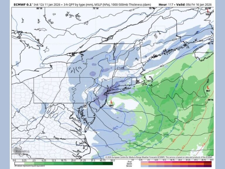
PENNSYLVANIA — A major winter storm is expected to impact Pennsylvania from Friday afternoon through Saturday, bringing the potential for heavy snow, sleet, and significant freezing rain across large sections of the state. Meteorologists warn that this storm could become one of the more disruptive winter systems of the season, with 6–12 inches of snow possible in some regions and over half an inch of freezing rain in others.
Alberta Clipper System Strengthens As Moisture Surges Into Pennsylvania
Experts describe this developing system as an “Alberta clipper on steroids”, with precipitation overrunning the state from northwest to southeast. A strong ridge in the western Atlantic, positioned off the coast of the Carolinas, will pump warm, moisture-rich air into the storm. At the same time, the associated cold front from the clipper will drive colder air into Pennsylvania.
This setup creates a major battleground atmosphere, with warm and cold air clashing over the state. The result is a storm capable of producing heavy snowfall, multiple hours of sleet, or significant icing, depending on location.
Snow, Sleet And Ice All Possible Across Different Regions Of The State
Forecasters warn that the final precipitation type will vary across Pennsylvania. For many northern and central areas, this could be a 6–12 inch snowstorm, especially where colder air remains dominant. However, other parts of the state may experience several inches of snow followed by sleet, creating a dense, compact accumulation that is difficult to shovel.
In eastern and southeastern Pennsylvania, including regions around Philadelphia, there is a higher likelihood of a rain or freezing rain solution. Experts caution that freezing rain amounts of 0.50 inches or more are possible in parts of eastern PA, increasing the risk of power outages, tree damage and extremely hazardous travel.
Greatest Risk In NEPA, Lower Impact In SWPA
The greatest storm impacts are expected in Northeast Pennsylvania (NEPA), where colder temperatures and stronger lift make heavier snow or ice more likely. Southwest Pennsylvania (SWPA) is expected to see lower impacts initially, but will still face wintry weather as the system moves southeast.
While Philadelphia may not experience the highest totals, forecasters emphasize the city is not completely out of danger, as even light freezing rain could disrupt travel.
Storm Track Still Shifting, But Risk Remains High
Meteorologists caution that this storm will “windshield wiper” back and forth in forecast models before Friday, making it difficult to pinpoint exact totals. However, the trend this winter has been stronger and colder storms, suggesting the potential for a high-impact event remains elevated.
Officials urge residents to remain alert, monitor updates, and prepare for the possibility of difficult travel, icy conditions, and heavy winter precipitation across the state. If you live in Pennsylvania and are preparing for this winter storm, share your updates and follow ongoing coverage at SaludaStandard-Sentinel.com.