Major Severe Storm Outbreak Expected Friday Across Illinois, Iowa, Oklahoma and Texas With Tornadoes, 70+ MPH Winds and Giant Hail Possible
UNITED STATES — Meteorologists are warning that a large and potentially dangerous severe weather outbreak could unfold Friday across several central U.S. states, with storms expected to stretch from Illinois and Iowa down through Oklahoma and Texas.
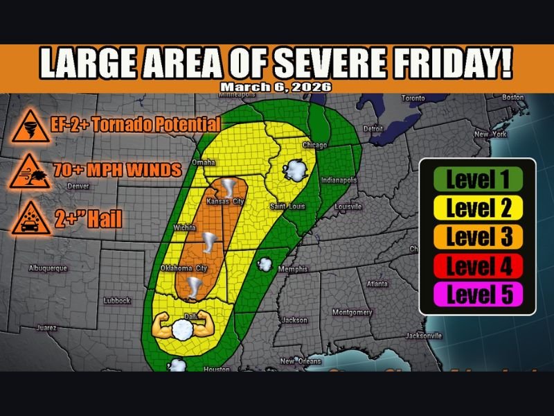
Forecasters say the setup could produce strong tornadoes, destructive wind gusts over 70 mph, and hail larger than two inches, making it one of the most widespread severe weather events of the year so far.
Storm System Could Impact a Large Portion of the Midwest and Southern Plains
Weather analysts say the system developing for Friday could affect a broad corridor of the country, spanning parts of the Midwest, Plains, and southern states.
Forecast maps show the threat zone stretching from Illinois and Iowa southward through Missouri, Kansas, Oklahoma, and Texas, with millions of residents potentially facing severe thunderstorms as the system moves east.
Meteorologists warn that the wide geographic coverage means storms may develop in several clusters throughout the day, making it important for residents across the region to stay alert.
Conditions Favor Strong Tornadoes and Giant Hail
According to weather experts monitoring the event, very strong wind shear in the atmosphere will create an environment supportive of severe storms capable of producing tornadoes.
The greatest concern lies in areas highlighted under Level 3 severe risk, where atmospheric conditions may allow storms to organize into powerful supercells.
Those storms could produce:
- EF-2 or stronger tornadoes
- Wind gusts exceeding 70 mph
- Hail larger than 2 inches in diameter
Large hail often forms early in severe storms before the systems evolve into larger storm lines capable of producing widespread damaging winds.
Cold Front Speed Could Determine Tornado Threat
Forecasters say some uncertainty remains regarding how storms will organize Friday because the event depends heavily on the speed of an approaching cold front.
If the front slows down and aligns properly with atmospheric instability, storms could remain discrete supercells longer, increasing the chances for significant tornado development.
However, if the front moves faster, storms may transition quickly into linear storm systems, which typically produce damaging straight-line winds and occasional spin-up tornadoes instead. Either scenario would still bring a dangerous round of severe weather across the region.
Severe Weather Season Now Underway Across Central U.S.
Meteorologists note that the setup developing Friday is typical of the early stages of the spring severe weather season, when warm, moist air from the Gulf of Mexico collides with cooler air from the north.
This combination often produces powerful thunderstorms capable of impacting multiple states in a single day. Residents across the threatened areas are encouraged to review their severe weather plans, ensure they can receive weather alerts, and remain prepared in case tornado warnings are issued.
Severe weather events like this can develop rapidly, especially during the afternoon and evening hours when atmospheric instability peaks. If you live in one of the states expected to be affected, what preparations are you making ahead of Friday’s storms? Share your thoughts or safety tips with the community at SaludaStandard-Sentinel.com.