Major Midwest Snowstorm Expected Sunday as Canadian Cold Collides With Gulf Moisture, Bringing Double-Digit Snow Totals
UNITED STATES — A significant snowstorm is expected to develop across parts of the Upper Midwest beginning Sunday as a surge of cold Canadian air collides with warm, moisture-rich air moving north from the Gulf of Mexico.
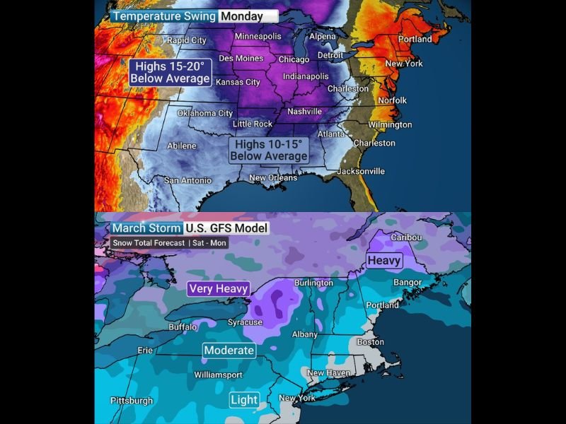
Meteorologists say this clash of air masses could produce a widespread swath of heavy snow stretching across several Midwestern states. Early forecast models indicate the most intense snowfall may extend from southern Minnesota through Wisconsin and into northern Michigan. In this scenario, several communities could see double-digit snowfall totals as the storm strengthens while moving through the region.
Upper Midwest Expected to See the Heaviest Snow
Weather models currently point to the Upper Midwest as the region most likely to experience the storm’s most intense snowfall.
Areas including southern Minnesota and northern Michigan appear to be within the potential corridor for the heaviest snow accumulation. Forecast projections suggest that a broad zone of heavy snow could develop as the storm organizes and spreads eastward. Cities such as Minneapolis, Rochester, and Des Moines are among those that could be impacted by the system as it begins to intensify Sunday.
As the storm tracks farther east, additional cities including Madison, Milwaukee, Chicago, Grand Rapids, Marquette, Detroit, and Indianapolis may also experience significant snowfall. Meteorologists emphasize that exact snowfall totals and the precise track of the storm could still change as the system develops.
Cold Canadian Air Driving the Snowstorm Setup
The storm system is forming as a large surge of cold air pushes southward from Canada into the central United States.
At the same time, warm and moist air from the Gulf of Mexico is moving northward into the same region. When these two contrasting air masses collide, they create conditions favorable for widespread precipitation.
Because temperatures are expected to remain cold across much of the Upper Midwest, that precipitation will likely fall as snow across a broad region. This setup is a classic pattern for producing large winter storms during the late winter and early spring season.
Storm May Bring Less Snow to the Northeast
While the Midwest could see heavy snowfall, forecast models suggest that the northeastern United States may experience a different outcome.
Both the GFS and European weather models currently indicate that the storm’s main low-pressure center could move toward Ontario and Quebec. If that track holds, it would limit the amount of snow reaching many parts of the Northeast.
Instead, portions of the Northeast may see more rain during the early stages of the storm before possibly transitioning to snow late Monday night or early Tuesday morning. Meteorologists say the exact balance between rain and snow in the Northeast will depend heavily on the storm’s final track.
Colder Temperatures Expected After the Storm
Following the storm system, colder-than-average temperatures are expected to spread across much of the eastern United States.
Forecast outlooks suggest temperatures could fall 10 to 15 degrees below seasonal averages across several regions early next week. This colder air could linger through St. Patrick’s Day, bringing a noticeable chill following the storm’s passage.
Weather experts will continue monitoring the evolving storm track in the coming days as forecast models refine the expected snowfall totals and impact zones. Readers who live in regions expected to be affected by the storm can follow ongoing weather coverage and share local conditions at SaludaStandard-Sentinel.com.