Maine and New England Face Light Snow, Bitter Cold, and a Complex Midweek Storm Pattern From Monday Through Friday
MAINE — Forecast data indicates a disturbance moving through New England late Monday morning into Tuesday morning, bringing light snow accumulations and extremely cold temperatures, followed by a more complex storm pattern developing later in the week. The system appears fast-moving, with snowfall amounts generally light but widespread across the region.
Meteorologists note that the setup closely resembles recent events, with coating-level snow in some areas and localized totals reaching a few inches, particularly farther north. While impacts are expected to remain limited early in the week, the combination of snow timing and sharp cold may still create hazardous conditions.
Light Snow Expected Monday Into Tuesday Morning
Snow accumulation maps show coating to light snowfall across much of Maine, New Hampshire, Vermont, Massachusetts, and northern Connecticut, with 1–3 inches possible in select inland locations. Coastal and southern areas are more likely to see minimal accumulation, with snow remaining light in intensity.
The disturbance is expected to enter the region late Monday morning, intensify modestly during the evening hours, and exit by Tuesday morning, limiting the duration but still affecting travel during overnight and early-morning hours.
Event Timing Shows Overnight and Early Morning Impacts
Timing graphics indicate that snow onset will vary by location, beginning as early as midday in western areas and peaking during the evening and overnight hours. Ending times range from late night to early Tuesday morning, depending on location and elevation.
Because this system contains multiple moving parts, meteorologists caution that timing may shift slightly, but the overall window of impact remains Monday afternoon through early Tuesday.
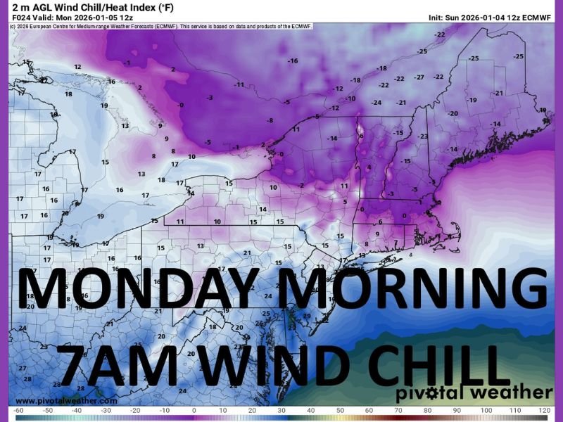
Extreme Cold Follows Behind the Snow
Temperature data shows very cold air settling in Monday morning, with dangerously low wind chills across northern and interior New England. Some locations may experience temperatures well below seasonal averages, making even brief outdoor exposure uncomfortable.
Officials stress that cold will be a bigger concern than snowfall totals, especially during the morning commute and overnight hours when wind chills are lowest.
Midweek Storm Signals Show Mixed Precipitation Potential
Looking ahead, forecast guidance highlights another storm system developing late Tuesday into Wednesday, which could bring rain and sleet to southern areas and snow farther north, depending on temperature profiles.
A separate system on Friday currently appears warmer, with precipitation leaning toward rain across much of the region, though confidence remains lower this far out.
What Residents Should Expect
While no major snowstorm is expected early in the week, the combination of light snow, icy conditions, and extreme cold may still impact travel and daily routines. Residents are encouraged to monitor updates closely, especially as the midweek system evolves. SaludaStandard-Sentinel will continue tracking forecast updates and provide timely coverage as confidence increases.