Louisiana, Mississippi, Alabama, Florida, Georgia, and the Carolinas Show Up in Wild GFS “Frankenstorm” Run for Feb. 15, 2026
UNITED STATES — A dramatic long-range GFS model run is making the rounds online after depicting a deep low-pressure system in the Gulf of Mexico around February 15, 2026, with potential impacts stretching from Louisiana and Mississippi through Alabama and Florida, then up into Georgia and the Carolinas—but the same forecast discussion attached to the graphic also emphasizes that this is far-out guidance and not a storm people should treat as locked in.
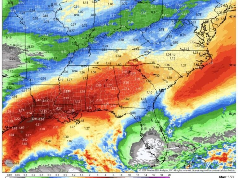
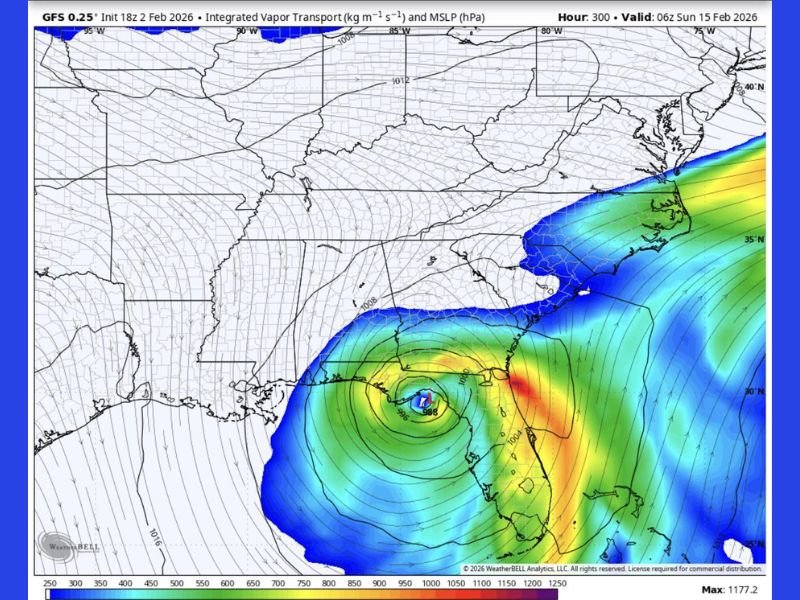
What the Model Image Actually Shows for Feb. 15
The forecast map provided is labeled as a GFS 0.25° output with Integrated Vapor Transport and Mean Sea Level Pressure, valid early Sunday, Feb. 15, 2026. It depicts a tightly wound circulation in the northern Gulf with a central pressure marked near 988 mb, a level that would imply a strong storm system if it were real and verified at shorter range.
The image also shows a concentrated plume of moisture aimed into parts of the Southeast—one of the key reasons a scenario like this grabs attention. A system with this structure would typically raise concerns for heavy rainfall, strong winds, and a sharp boundary where different hazards can stack up quickly.
Why People Are Calling It a “Frankenstorm” Setup
The text in the graphic explains the issue clearly: it’s not presenting this as a hurricane or a typical winter storm. Instead, it’s describing a chaotic hybrid scenario—snow on one side, severe weather on the other, with pressure falling quickly and winds ramping up in a way that looks over-the-top for February.
That “two-season” look is what fuels the viral reaction. When a model shows a major Gulf low while winter air still exists to the north, it can create the kind of map that appears to combine multiple hazards at once, even if the setup is unlikely to verify exactly as shown.
The Key Warning: This Is Long-Range, Not a Confirmed Forecast
Even the post tied to the map stresses that it’s “way too early” and that this is likely a long-range fever dream that “probably won’t happen.” That matters because at this distance—roughly 10–14 days—single model runs can swing wildly from one cycle to the next.
One run can paint a huge storm, the next run can erase it entirely, and the most realistic outcome often ends up being something far less dramatic than the loudest graphic.
What a Gulf Low Like This Would Mean for the Southeast if It Ever Held
If a strong Gulf low were to develop in a more realistic way later in the month, the most common real-world impacts in Florida, Georgia, South Carolina, North Carolina, Alabama, Mississippi, and Louisiana would be things like periods of heavy rain, localized flooding, strong coastal or inland wind gusts, and the possibility of severe thunderstorms depending on where warm, humid air sets up.
Farther north and west of the storm track, colder air can sometimes create wintry precipitation, but those details are exactly the kind that cannot be trusted from a single long-range snapshot.
What to Watch Instead of Viral Model Screenshots
The most useful takeaway from this graphic isn’t that a monster storm is guaranteed—it’s that winter patterns may still be active enough in mid-February to keep the atmosphere “unstable”, meaning sharp contrasts and stronger storm systems remain possible somewhere in the eastern half of the country.
The smarter move is tracking whether multiple model runs and multiple forecast sources start trending the same way as the date gets closer, rather than reacting to one extreme image.
If you’ve seen this GFS “Frankenstorm” map being shared in your area, do you think it’s just internet hype—or a sign winter still has tricks left? Share what you’re hearing locally and keep following updates at SaludaStandard-Sentinel.com.