Long-Range Models Hint at Possible Late-January Winter Storm Pattern for Texas, Louisiana, Mississippi, Alabama, Georgia, and the Carolinas
UNITED STATES — New long-range model runs are stirring attention across the South as early data hints at a possible late-January winter storm pattern that could impact Texas, Louisiana, Mississippi, Alabama, Georgia, South Carolina, and North Carolina. Forecasters stress that these signals are not a guaranteed forecast—but the pattern showing up in the extended GFS ensembles has captured enough consistency to draw early interest.
The potential setup is reminiscent of the surprise winter events the South has seen in past years, with models showing snow probabilities returning to the Gulf States and sweeping northeastward toward the Carolinas and Mid-Atlantic.
Models Show Southern Snow Signal—But Confidence Remains Low
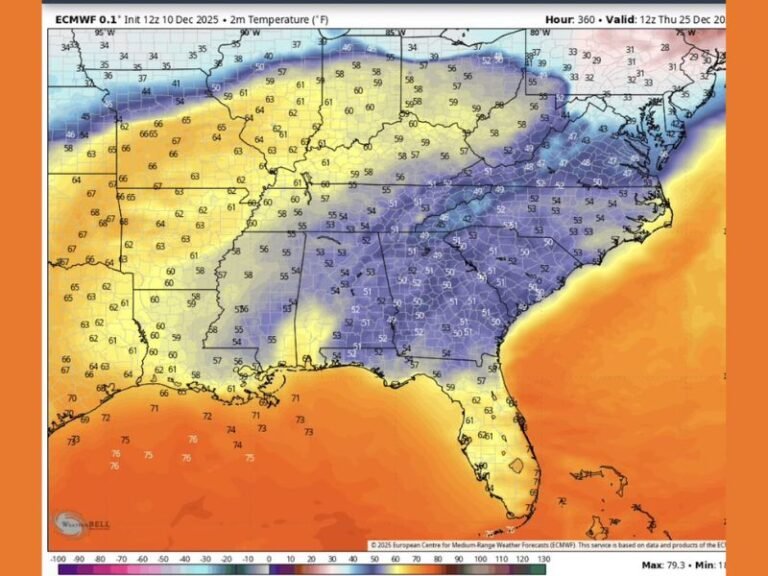
The latest extended GFS snowfall projection shows:
- A snow corridor stretching from Texas into Louisiana and Mississippi,
- Light to moderate accumulations into Alabama and Georgia,
- A broader winter signal expanding into South Carolina and North Carolina,
- Heavier modeled snow across the Midwest, Great Lakes, and Northeast.
Meteorologists caution that long-range snow maps are not forecasts but pattern indicators. Still, the current data suggests that winter may attempt a comeback heading into the final week of January.
Why Forecasters Are Paying Attention
Even with low confidence, experts note several ingredients worth watching:
- A return of colder air into the central and eastern U.S.
- A possible southern-stream disturbance, which historically produces Gulf-coast winter events
- Model consistency showing repeat signals over multiple runs
These early hints do not guarantee a storm, but they mark a noticeable shift from the warm pattern expected next week.
Southern Residents Should Monitor Trends
While it is too early to predict exact impacts, past January patterns demonstrate how quickly winter weather can develop in the South.
If the pattern verifies, residents across:
- Texas, Louisiana, Mississippi, Alabama, Georgia, and
- South Carolina and North Carolina
could face travel disruptions, school impacts, or first significant snowfall potentials of the season.
Forecasters emphasize that even the hint of a winter event can have outsized effects in Southern states, where cold-weather infrastructure and road treatment are limited.
Model Uncertainty Remains High
Weather experts remind readers:
- Long-range models often exaggerate snowfall
- Small shifts in atmospheric alignment can completely erase or amplify Southern snow threats
- Reliable projections typically form within 5–7 days of the event
For now, this remains a pattern to watch, not a forecast to depend on.
Looking Ahead
With mid-January bringing a warm spell, the potential late-month flip has caught the attention of meteorologists and residents alike. If colder air dives south and a Gulf disturbance develops, the South could see a notable winter event.
Stay updated with evolving model trends and Southern winter storm coverage at SaludaStandard-Sentinel.com, where forecasts will be updated as confidence grows.