Light Snow Showers and Black Ice Threat Expected Across Western North Carolina and Upstate South Carolina Overnight
NORTH CAROLINA & SOUTH CAROLINA — A narrow band of winter weather is expected to develop late tonight across parts of the southern Appalachians and nearby Piedmont, bringing light snow showers and a risk of patchy black ice from late evening through the overnight hours, according to the latest regional weather guidance.
Meteorologists say snow showers are forming along the Blue Ridge Escarpment and will gradually drift eastward into the Piedmont as the night goes on. While this will not be a widespread or high-impact snow event, residents in several western North Carolina and Upstate South Carolina communities could briefly see snowflakes — and more importantly, slick spots by early morning.
Where Snow Showers Are Most Likely
The areas most likely to see snow include locations stretching from Greenville, South Carolina, northward through Spartanburg, and into parts of York County, with additional light snow possible farther north and east into western North Carolina.
Most communities will see only a trace of snowfall, but forecasters caution that localized heavier snow showers could briefly produce up to one inch of accumulation, especially in elevated terrain or areas closer to the escarpment.
Cities and towns near Asheville, Waynesville, Morganton, and surrounding foothill communities are also within the zone where light snow may develop late tonight.
Black Ice a Bigger Concern Than Snowfall
While snow amounts are expected to be limited, black ice may pose the greater hazard. Temperatures are forecast to drop overnight, allowing any melted snow or moisture to refreeze on cold surfaces.
Drivers are urged to use caution on:
- Bridges and overpasses
- Untreated roads
- Ramps and elevated surfaces
Pedestrians should also watch for slippery conditions on sidewalks, driveways, and parking lots, particularly early Thursday morning when temperatures are coldest.
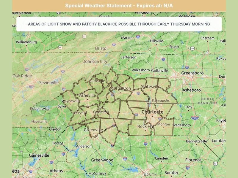
Special Weather Statement Remains in Effect
A Special Weather Statement has been issued for the region, highlighting the potential for areas of light snow and patchy black ice through early Thursday morning. While no winter storm warnings or advisories are currently in place, officials stress that even small amounts of snow and ice can create dangerous travel conditions.
What to Expect by Thursday Morning
Snow showers are expected to taper off overnight, with conditions gradually improving by mid to late Thursday morning as temperatures rise above freezing. Any remaining slick spots should melt as daylight and milder air move in.
Forecasters emphasize that this is a short-lived winter weather event, but one that could still cause minor disruptions during the early morning commute.
Safety Tips for Residents
- Slow down if traveling late tonight or early Thursday
- Leave extra space between vehicles
- Avoid sudden braking on potentially icy roads
- Wear shoes with good traction when walking outdoors
Residents are encouraged to stay alert for updates as conditions evolve overnight.
Continue following Saluda Standard-Sentinel for the latest local weather updates, overnight conditions, and early morning travel impacts across the Carolinas.