Life Threatening Storms With 100 MPH Winds and Embedded Tornadoes Tearing Southeast Across Kansas Approaching Wichita Hutchinson and Salina at 9:50 PM CDT
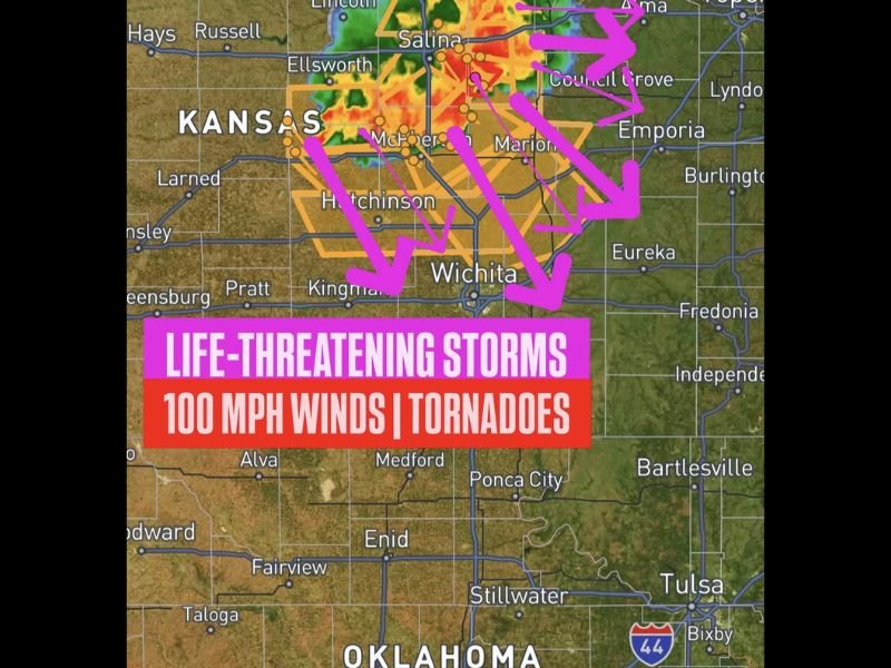
WICHITA, KS — Life-threatening and destructive storms were tearing southeast across central Kansas Monday night at 9:50 p.m. CDT, producing catastrophic 100 mph winds and embedded tornadoes as the fast-moving storm complex bore down on Wichita, with forecasters warning the city had less than one hour before impact.
The Immediate Threat
The storm system moving southeast across Kansas at the time of the warning was producing winds estimated at 100 mph — well into the range capable of catastrophic structural damage, downed power lines across entire counties, and widespread destruction to vehicles and infrastructure. Embedded tornadoes rotating within the larger storm complex added a second life-threatening dimension to an already extreme event.
Wind gusts of this magnitude can collapse poorly constructed buildings, strip roofs from well-built structures, and turn any unsecured outdoor objects into deadly projectiles. This was not a situation for shelter-in-place hesitation — immediate action was required for anyone in the path.
Communities in the Direct Path
Radar and storm track data placed the storm complex on a direct southeast track through McPherson, Hutchinson, and Marion before converging on the Wichita metro — the largest city in Kansas. The warning polygon visible on radar covered a broad swath of central Kansas including Ellsworth, Salina, Council Grove, and Kingman, all falling under active severe weather warnings as the complex accelerated southeastward.
Wichita, with a metro population of several hundred thousand residents, faced the most urgent timeline with storms expected to arrive within the hour of the 9:50 p.m. CDT issuance.
What Made This Event Especially Dangerous
Nighttime severe weather events of this magnitude carry dramatically elevated danger. With most residents asleep or winding down for the evening, the window for receiving and acting on warnings is compressed. A storm producing 100 mph winds and tornadoes simultaneously represents one of the most dangerous combinations possible in a single convective event.
The southeast track also meant the storm would continue threatening communities beyond Wichita into southern Kansas and potentially northern Oklahoma through the overnight hours.
Immediate Safety Actions Required
Any resident inside the warning area was urged to move immediately to the lowest floor of a sturdy structure, away from all windows, and cover their head and neck. Do not wait to see or hear the storm before seeking shelter. For continuing coverage of this life-threatening Kansas storm event and severe weather across the United States, visit SaludaStandard-Sentinel.com.