Late-January Winter Weather Setup Could Bring Snow and Ice to Oklahoma, Texas, and Arkansas as Forecast Confidence Slowly Builds
OKLAHOMA — Early forecast signals are beginning to point toward a potential winter weather event late next week across parts of Oklahoma, Texas, and Arkansas, as cold air becomes established and weather models hint at a possible window for snow and ice between January 23 and January 25.
Forecasters stress that this is not an official forecast yet, but the setup is becoming one that warrants close monitoring as confidence gradually increases.
Cold Air Appears to Be Locking In Across the Region
Weather data indicates that cold Arctic air will already be in place across much of the southern Plains and lower Midwest ahead of this potential system. This cold foundation is a key ingredient for winter precipitation, especially when warmer, moisture-rich air attempts to override it from the south.
Meteorologists note that once cold air settles in at the surface, it becomes much easier for snow, sleet, or freezing rain to develop if precipitation arrives.
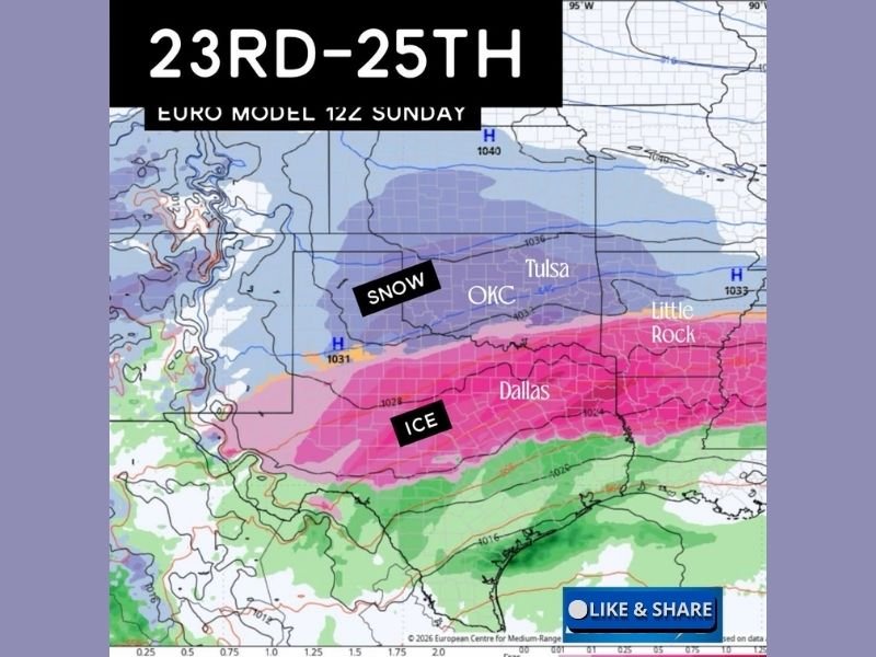
Forecast Models Hint at a Snow-to-Ice Transition Zone
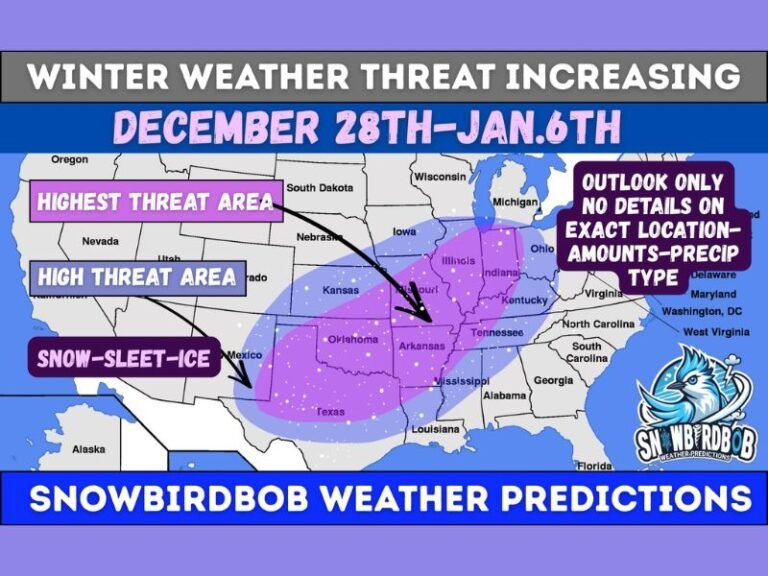
Recent model guidance suggests a classic winter weather gradient setting up across the region. Northern areas of Oklahoma, including parts near Oklahoma City and Tulsa, currently show signals favoring snow, while southern Oklahoma and north Texas appear more likely to sit in a mixed or ice-dominated zone.
Across north Texas, including the Dallas–Fort Worth area, models are hinting at a freezing rain or sleet scenario, while Arkansas could see a sharp transition zone where small temperature shifts determine snow versus ice.
Small Changes Could Dramatically Shift Impacts
Forecasters emphasize that minor shifts in track, timing, or temperature profiles will make a major difference in who sees impacts and who does not. A change of just a few miles north or south could dramatically alter precipitation types. This kind of setup is highly sensitive, and confidence typically remains low until 48–72 hours before the event.
January 23–25 Window Being Watched Closely
The primary window for potential impacts currently appears to be late next week, centered around January 23 through January 25. During this period, model runs suggest the interaction between entrenched cold air and incoming moisture could create hazardous travel conditions in affected areas.
At this stage, meteorologists caution against focusing on specific snowfall or ice totals, noting that trend consistency is more important than any single model run.
Residents Encouraged to Stay Weather-Aware
While no action is required yet, residents across Oklahoma, Texas, and Arkansas are encouraged to stay weather-aware, especially if travel plans fall within the late-January timeframe. Forecasters say updates will become more refined as confidence improves and the forecast window narrows.
As winter patterns continue to evolve, readers are invited to share what they are seeing locally and how conditions are changing in their area. Stay informed with continued updates and regional coverage at SaludaStandard-Sentinel.com.