Kentucky, Tennessee, Indiana and Ohio Brace for Extreme Weather Whiplash as Wind Chills Drop to 5 Degrees Before Temperatures Surge Near 80 by Friday
KENTUCKY — A dramatic weather swing is unfolding across Kentucky, Tennessee, Indiana, and Ohio, where residents are bracing for a sharp drop in temperatures and bitter wind chills before a rapid warm-up pushes highs toward 80 degrees by the end of the week.
Forecasters say the region will experience one of the most extreme temperature swings of the season, transitioning from near-winter conditions to springlike warmth in just a matter of days.
Bitter Cold Arrives After Early Week Storms
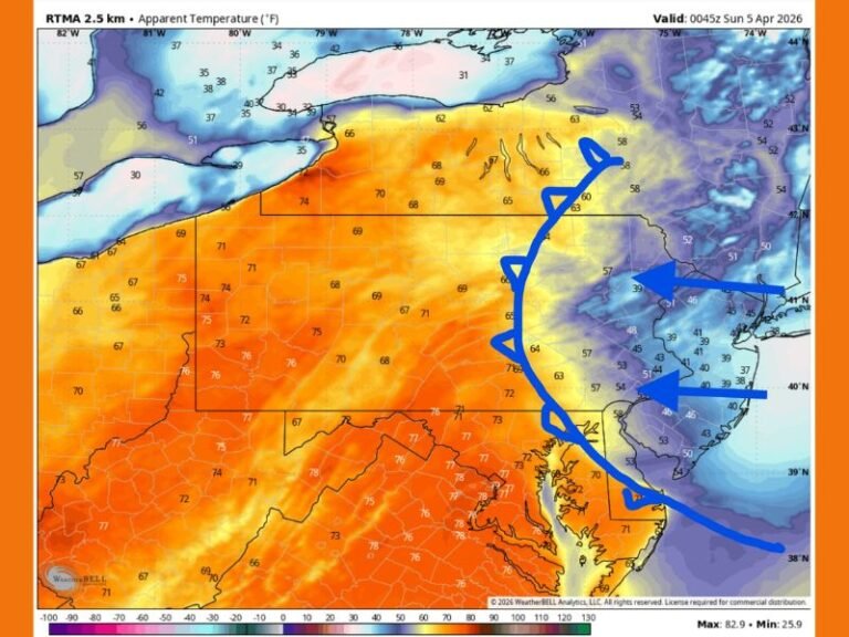
Following early week storms that brought rain and severe weather, a strong cold air mass is now sweeping into the region. By Monday afternoon into Tuesday, temperatures are expected to plunge significantly, with wind chills dropping into the 5 to 15 degree range across multiple states.
This cold blast will be especially noticeable given the recent mild conditions, creating a sharp contrast that could catch many residents off guard. Northern areas, particularly across Indiana and Ohio, may feel the coldest impacts, while Kentucky and Tennessee will also see a significant chill.
Meteorologists warn that gusty winds will make it feel even colder, increasing the risk of discomfort and exposure for anyone spending extended time outdoors.
Rapid Temperature Rebound Expected by Midweek
Despite the bitter cold at the start of the week, conditions will shift quickly as warmer air begins to move into the region. By midweek, temperatures will steadily climb, setting the stage for a dramatic warm-up.
Forecasters highlight that this type of rapid rebound is typical during the transition from winter to spring, though the magnitude of this swing is particularly notable. Residents can expect a noticeable improvement in daytime temperatures, with each day feeling progressively warmer.
Highs Near 75 to 80 Degrees by Friday
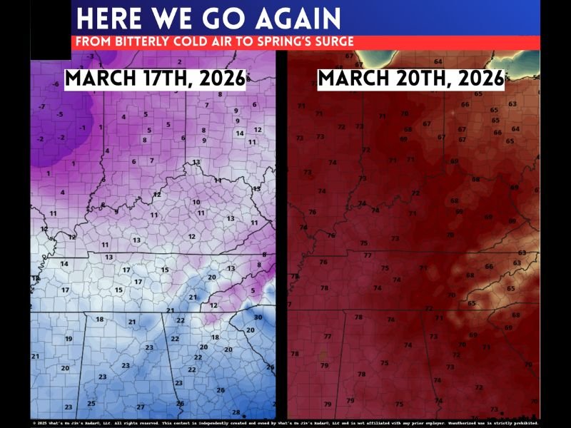
By Friday, temperatures across Kentucky, Tennessee, Indiana, and Ohio are expected to reach into the mid to upper 70s, with some areas approaching 80 degrees. This marks a complete reversal from the early-week cold, bringing conditions that feel more like late spring than early March.
The arrival of spring is officially set for Friday morning, and the weather pattern will reflect that shift, with widespread warmth dominating the region. This sudden transition may also increase the potential for additional storm systems as warm and cool air masses continue to clash.
Extreme Weather Swings Highlight Seasonal Transition
Meteorologists describe this pattern as a classic example of springtime volatility, where rapid changes in temperature and weather conditions are common. However, the intensity of this particular shift — from wind chills near 5 degrees to near 80-degree warmth — makes it especially noteworthy.
Such swings can have wide-ranging impacts, from increased energy demand during cold periods to early-season severe weather risks as warmth returns. Residents are encouraged to stay prepared for rapidly changing conditions and adjust plans accordingly.
Residents Advised to Prepare for Both Cold and Warm Conditions
With such a dramatic shift expected in a short time frame, officials recommend preparing for both extremes. Layered clothing, heating precautions, and awareness of changing forecasts will be key during the early part of the week.
Later in the week, the focus will shift to enjoying warmer conditions while staying alert for any developing weather systems that could accompany the warming trend. If you’re experiencing this rapid weather swing in your area, share your thoughts and updates with us. Stay informed with the latest forecasts on SaludaStandard-Sentinel.com.