Kentucky, Southern Ohio, and Tennessee Face Sharp Snow-to-Ice Divide as January 24–26 Winter Storm Takes Shape
KENTUCKY — A developing winter storm expected between Friday, January 24 and Sunday, January 26 is setting up a razor-thin divide between heavy snow and dangerous ice across Kentucky, southern Ohio, and Tennessee, according to the latest high-resolution forecast data. Meteorologists warn this will not be a uniform storm, but rather one where impacts change dramatically over short distances, making travel and preparation decisions especially challenging.
Understanding the Snow and Ice Zones
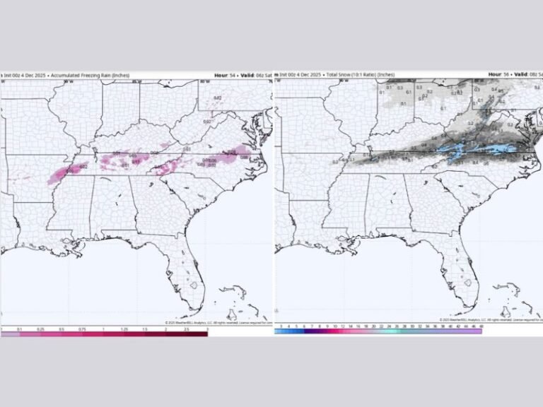
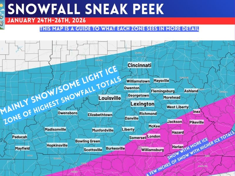
The newest “snowfall sneak peek” guidance highlights two primary impact corridors across the region, clearly defined by color-coded zones:
- Blue Zone: Indicates a higher probability of mainly snow and the highest snowfall totals
- Magenta Zone: Signals accumulating snow mixed with a significant amount of ice, including sleet and freezing rain
This setup means some communities will deal primarily with plowable snow, while others just miles away may face power-threatening ice accumulation.
Where Snowfall Is Most Likely
Much of central and northern Kentucky, including areas around Louisville, Lexington, Bowling Green, Owensboro, and Georgetown, currently sits within the blue snow-dominant zone. Portions of southern Ohio, including areas near Cincinnati, also fall into this category.
In these locations, snow appears to be the primary precipitation type, with only limited ice involvement. While exact totals are still being refined, forecasters note this zone carries the best chance for the highest snowfall totals, especially if colder air holds firm.
Ice Risk Increases Farther South and East
Farther south and east, the forecast shifts quickly into the magenta transition zone, which stretches across southeastern Kentucky and into Tennessee. Cities such as Hazard, Jackson, Pikeville, Williamsburg, and parts of the Cumberland Plateau lie within this more hazardous corridor.
Here, snow may begin the event, but warmer air aloft could lead to sleet and freezing rain, increasing the risk of:
- Ice-coated roads
- Tree damage
- Power outages
- Extremely dangerous driving conditions
Meteorologists stress that ice accumulation, even in smaller amounts, often causes more disruption than heavy snow.
Why This Forecast Is Tricky
What makes this storm particularly concerning is the sharp north-to-south gradient. Forecast models show conditions changing dramatically over distances of 20–40 miles, meaning a slight shift in storm track could move the snow-ice line significantly.
This uncertainty is why forecasters are emphasizing impact zones rather than exact totals at this stage.
Timing and What Comes Next
At this point, the storm is expected to unfold from late Friday through Sunday, with preliminary timing and accumulation estimates expected by Thursday night. That update should provide clearer guidance on:
- When precipitation begins in each area
- How long snow or ice persists
- Which communities face the highest risk of outages or impassable roads
What Residents Should Do Now
Residents across Kentucky, southern Ohio, and Tennessee should begin preparing now, especially those near the snow-to-ice transition zone. Recommended steps include:
- Monitoring local forecasts closely
- Avoiding unnecessary travel plans for the weekend
- Ensuring vehicles, generators, and emergency supplies are ready
- Preparing for possible power disruptions in ice-prone areas
Because small forecast changes could have big local consequences, staying informed will be critical as this system approaches. Have you experienced major winter storms like this before? Share your thoughts and follow ongoing updates at SaludaStandard-Sentinel.com, where we’ll continue tracking this evolving situation closely.