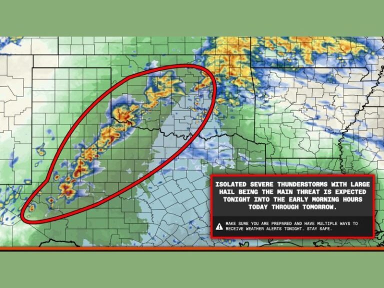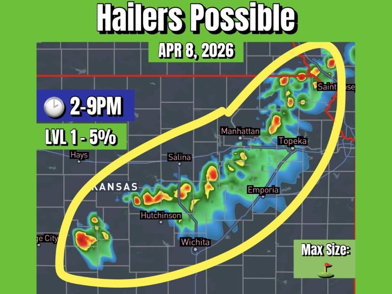
Kansas Storm Risk Targets Wichita, Hutchinson, Salina, Topeka and Manhattan With Hail Possible Up to Golf Ball Size Wednesday Afternoon
KANSAS — A developing weather pattern is expected to bring scattered thunderstorms across Kansas on Wednesday, with the potential for hail-producing storms from Wichita through Salina, Manhattan, Topeka, and into northeastern parts of the state.
The risk window is expected to develop during the afternoon and continue into the evening hours, with the most active period likely between 2 PM and 9 PM.
Scattered Storms Expected Across Central and Eastern Kansas
Storm development is expected to begin during the afternoon as weak disturbances move across the state. These ripples of energy will interact with available moisture and instability, helping trigger scattered thunderstorms.
The primary corridor of activity appears to stretch from southwestern Kansas through central regions near Hutchinson and Wichita, extending northeast toward Salina, Manhattan, and Topeka. While storm coverage will remain scattered, some cells could briefly intensify.
Hail Risk Present but Limited in Coverage
The main concern with these storms is the potential for hail, though the overall severe threat remains relatively low. Most storms are expected to stay below severe limits, but a few stronger cores could produce hail.
Forecast guidance suggests hail sizes may range from small “pocket change” hail to potentially golf ball-sized hail in isolated locations. This type of setup typically leads to brief but intense storm cells capable of producing localized impacts.
Timing Window Focused Between Afternoon and Evening
The most favorable timing for storm development is expected between 2 PM and 9 PM, when daytime heating combines with incoming atmospheric energy.
During this window, storms will have the best chance to strengthen and produce hail, particularly across central and northeastern parts of the state. After sunset, storm activity may begin to weaken as instability decreases.
Severe Risk Remains Low but Not Zero
Overall, this setup is categorized as a low-end severe threat, with only a small percentage of storms expected to reach stronger levels.
However, even isolated severe cells can produce noticeable impacts, especially in areas directly under stronger storm cores. Residents should remain aware of changing conditions during the afternoon and evening hours.
Localized Impacts Possible in Stronger Storms
While widespread severe weather is not anticipated, localized impacts such as brief heavy rain, small hail, and gusty winds could occur.
Drivers may encounter reduced visibility during heavier downpours, and hail could cause minor damage in isolated spots. The scattered nature of storms means some areas may see little to no activity, while others could experience quick-moving but intense cells.
Midweek Storms Signal Changing Weather Pattern
This system marks the beginning of a more active weather pattern across Kansas, as conditions gradually become more favorable for springtime storm development. Although Wednesday’s risk remains limited, it signals a transition toward increased thunderstorm chances in the coming days.
Residents should stay updated as forecasts evolve and additional storm chances develop. Are you expecting storms in your area Wednesday afternoon? Share your local conditions and updates with us at SaludaStandard-Sentinel.com.