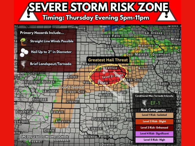
Kansas and Nebraska Under Thursday Evening Severe Storm Threat With 2 Inch Hail, Damaging Winds and Brief Tornado Risk Near Concordia Between 5 PM and 11 PM
KANSAS — A developing severe weather setup is expected to impact parts of northern Kansas and southern Nebraska Thursday evening, with forecasters highlighting a Level 2 “Slight Risk” and a growing concern for large hail and damaging winds.
The system is projected to intensify between 5 p.m. and 11 p.m., with the greatest concentration of severe storms expected near the Kansas-Nebraska border, including areas around Concordia. Conditions appear favorable for organized storm development, including supercell structures capable of producing significant hazards.
Level 2 Severe Risk Targets Northern Kansas and Southern Nebraska
The Storm Prediction Center has outlined a Level 2 risk zone stretching across northern Kansas into southern Nebraska, signaling an increased likelihood of scattered severe storms.
Within this zone, storms could develop rapidly during the late afternoon and strengthen into the evening hours. Cities including Salina, Beatrice, and nearby rural communities are positioned within the core risk area, where atmospheric conditions are most supportive of severe weather.
Surrounding regions, including parts of central Kansas and into western portions of the Midwest, fall under a lower Level 1 risk, indicating isolated severe storm potential.
Greatest Threat Includes Very Large Hail and Damaging Winds
The most significant concern with this system is the potential for very large hail, with some stones possibly reaching up to 2 inches in diameter. This size of hail can cause damage to vehicles, roofs, and crops, especially in open areas.
In addition to hail, strong straight-line winds are expected to accompany the storms. These winds could lead to downed tree limbs and localized power outages, particularly in areas where storms organize into clusters or lines. The combination of hail and wind makes this a multi-hazard event that could impact both urban and rural communities across the region.
Low Tornado Threat Still Present With Supercell Potential
While the tornado risk remains relatively low, it is not zero. The setup includes conditions that may support brief landspout-style tornadoes or weak tornado development, particularly if isolated supercells form.
Forecast guidance suggests that wind profiles in the atmosphere, including supportive hodographs, could allow storms to rotate. This increases the chance for short-lived tornado activity, especially in the most unstable parts of the risk zone. Any tornado that does develop is expected to remain on the weaker side, but could still pose localized danger.
Timing and Storm Development Window Thursday Evening
The primary window for severe weather is expected between 5 p.m. and 11 p.m., when daytime heating and atmospheric instability peak.
Storms may begin as isolated cells before potentially clustering together as the evening progresses. This transition could shift the main hazard from hail to wind as storms evolve.
Residents in the affected areas are advised to remain weather-aware during this timeframe, particularly those with outdoor plans or travel scheduled in the evening hours.
Concordia Area Emerges as Key Focus Zone
Among the highlighted areas, Concordia, Kansas stands out as a likely focal point for storm development. Forecast discussions suggest this region could see some of the strongest storm activity, making it a key location to monitor.
This area sits within the heart of the greatest hail threat zone, where atmospheric ingredients appear most favorable for intense storm updrafts capable of producing large hail. As the situation evolves, slight shifts in storm track could expand or shift the highest risk areas.
Residents across Kansas and Nebraska are encouraged to stay updated and prepared as conditions develop. If you are in the risk zone and experience severe weather, share your updates and join the discussion at SaludaStandard-Sentinel.com.