Kankakee, Illinois Tornado Explodes in Strength, Launches Record 5–6 Inch Hail and Sends Debris Flying Across Storm Path
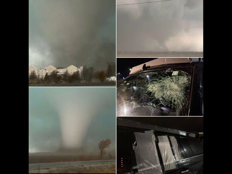
KANKAKEE, ILLINOIS — A rapidly intensifying tornado tore through parts of northeastern Illinois near Kankakee, producing extreme weather conditions that included record-sized hail measuring between five and six inches and powerful winds capable of hurling debris across the landscape.
Storm observers reported that the tornado strengthened quickly as a powerful supercell thunderstorm developed over the region. The storm not only produced a large visible tornado but also unleashed enormous hailstones that shattered windows and damaged vehicles as the storm moved through the area.
Images captured during the event show a massive tornado funnel forming beneath dark storm clouds while powerful winds bent trees and swept debris across roads and nearby fields.
Tornado Strengthened Rapidly Near Kankakee
Meteorologists and storm observers tracking the event reported that the tornado intensified extremely quickly once the supercell began organizing over northeastern Illinois.
The tornado developed within a powerful rotating thunderstorm structure that allowed the funnel to strengthen in a short period of time. Witnesses described the storm as rapidly evolving from a threatening supercell into a destructive tornado-producing system.
Photographs taken during the event show the tornado expanding as it moved across open land, with a wide funnel extending from the storm cloud to the ground. Rapid intensification is one of the most dangerous characteristics of tornado-producing storms because it can leave little time for residents to react.
Record-Sized Hail Accompanies the Supercell
One of the most remarkable aspects of the storm was the size of the hail produced within the supercell. Reports from storm observers indicated that hailstones measuring between five and six inches in diameter fell around the tornado. Hail of this size is extremely rare and can cause significant damage to vehicles, buildings, and windows.
Images taken after the storm show shattered glass on vehicles that were struck by the hail. In some cases, the force of the hail was strong enough to break windows completely. Hail of this magnitude typically forms inside powerful supercell storms where strong updrafts repeatedly carry hailstones upward through the storm, allowing them to grow larger before falling to the ground.
Multiple Tornadoes Reported During the Storm Chase
Storm observers following the outbreak reported seeing multiple tornadoes during the severe weather event.
The Kankakee tornado was the most intense, but additional tornadoes were reportedly observed during the same storm cycle. At least one satellite tornado formed near the primary funnel, and another tornado was later observed after the storm crossed into Indiana during the evening hours.
Satellite tornadoes are smaller tornadoes that rotate around a larger primary tornado, often forming within extremely powerful storm systems. These types of complex storm structures are typically associated with highly organized supercells capable of producing significant severe weather.
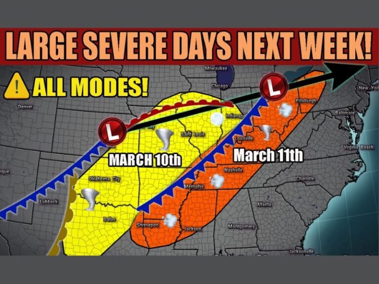
Active Start to March Severe Weather Season
Meteorologists say the storm is another example of how quickly severe weather season can ramp up during early spring across parts of the Midwest.
As warmer air begins to clash with colder air masses moving across the country, conditions can quickly become favorable for powerful thunderstorms capable of producing tornadoes, large hail, and damaging winds.
The outbreak near Kankakee highlights how rapidly storms can intensify once atmospheric conditions align. Weather experts continue to monitor additional storms moving eastward into Indiana and nearby states as the system evolves.
Residents across the Midwest are encouraged to stay alert for weather warnings and seek shelter immediately when tornado warnings are issued. Readers who witnessed the tornado or experienced storm damage in their communities can share their stories and follow continued updates at SaludaStandard-Sentinel.com.