Kankakee and Aroma Park Illinois Tornado Displays Rare Green White Haze as Giant 5 Inch Hail and Violent Winds Strike Region
KANKAKEE, ILLINOIS — A powerful tornado near Kankakee and Aroma Park delivered a rare and visually striking appearance as it tore through the region, accompanied by destructive hail and intense storm conditions.
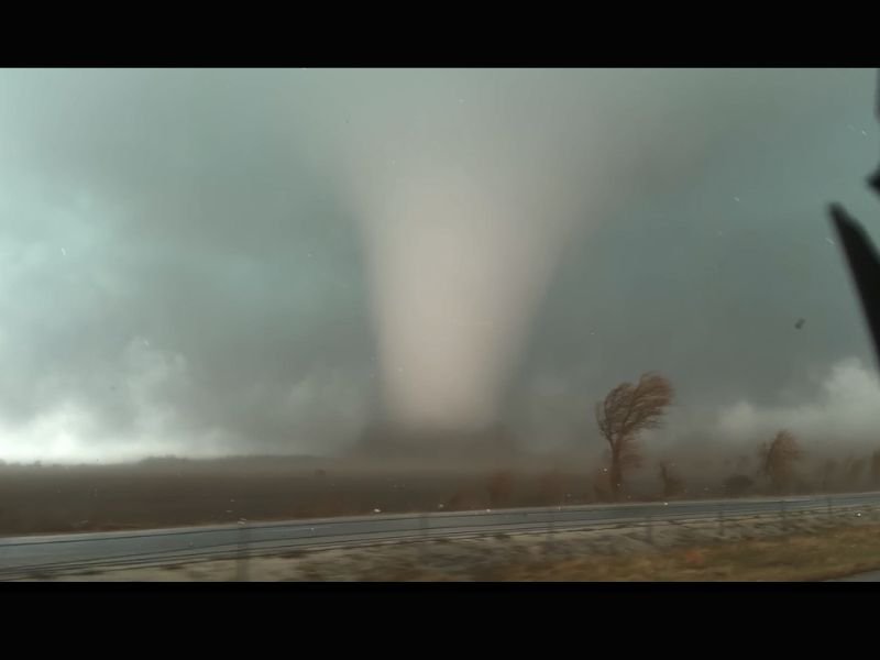
Observers described the tornado as having an unusual green and white coloration, a phenomenon not commonly seen even among experienced storm chasers.
Rare Tornado Appearance Captured Near Aroma Park
The tornado’s distinct color stood out immediately, with a ghostly white core surrounded by a green-tinted sky. Meteorologists say this type of coloration is often linked to high moisture content and large hail within the storm.
The hazy appearance around the tornado also reduced visibility of its finer structure, giving it a milky, blurred look as it moved across the landscape. This combination of color and haze is considered rare and is typically associated with particularly intense storm environments.
Storm Transition Contributed to Unique Structure
Experts indicate that the parent storm was undergoing a transition into a high-precipitation (HP) supercell at the time the tornado formed.
HP supercells are known for wrapping rain and hail around the tornado, which can obscure visibility and create unusual visual effects. The excess moisture in the storm likely contributed to the green hue seen in the sky. These types of storms are often more dangerous because the tornado can be partially hidden by precipitation.
Giant Hail Reported Moments Before Impact
In addition to the tornado, extremely large hail was reported in the area. Observations indicate hailstones exceeding 5 inches in diameter, large enough to cause significant property damage.
Such hail can shatter windows, damage vehicles, and pose a serious threat to anyone caught outdoors. The hail reportedly struck shortly after the tornado was observed, highlighting the storm’s rapid escalation. The presence of large hail further confirms the storm’s intensity and strong updraft structure.
Violent Winds and Rapidly Changing Conditions
The tornado was accompanied by strong winds that bent trees and reduced visibility due to blowing debris and precipitation.
Conditions deteriorated quickly as the storm moved through, leaving little time for preparation. This is characteristic of severe spring storms, where multiple hazards—including tornadoes, hail, and damaging winds—can occur simultaneously. Residents in the area experienced rapidly changing weather within minutes.
Event Highlights Dangers of Spring Severe Weather
This storm serves as a reminder of how volatile spring weather can be across the Midwest. Tornado season is ramping up, and storms are becoming more capable of producing extreme conditions.
The combination of warm, moist air and strong atmospheric dynamics creates an environment where severe weather can develop quickly and intensify without much warning. Preparedness and awareness remain critical during this time of year.
Have you ever witnessed a tornado or severe storm like this in your area? Share your experience and stay updated with the latest weather coverage at SaludaStandard-Sentinel.com.